|
 |
 |
 |
 |
|
|
|
|
|
|
Saturday, November 13 - 11 miles to Wagontongue Mountain (Elev gain/loss: +2430/-1310)
We had our usual late start, 10:55 a.m., thanks to a long leisurely breakfast with Jason and Julian, who had just arrived in town. The Post Office didnt open until 9:30 and we needed to send out our drift box, so there was no point in hurrying. Len and Zeke (his black lab) drove us out to the trail and walked a little way with us. It was a beautiful sunny day. We climbed from pinon to ponderosa country. We saw one truck, a hunter on an ATV and a couple of jack rabbits and squirrels. Getting water took time as Damian Spring was just a seep down by the trail, though there was a fairly good pool way up the draw. While Jim went scouting, I tried to clear out a pool down below, but it didnt do much good. After we filled our water bag, we began the long climb up Wagontongue Mountain, a 1300' climb in about 2 ½ miles. We stopped to build a cairn at the junction as there was no treadway there and the axe blazes were only noticeable if you knew where to look for them. I had been forewarned, but I imagine a lot of hikers get lost at the spring. Part of the trail was burned but it was pretty easy to follow, just a long climb with a full load of water. We stopped as soon as we could once we went over the ridge. Were back to walking along the Divide. For most of northern New Mexico, weve been far from the actual Continental Divide. It was easier and more scenic to route us through the National Forests than to try to deal with private property issues along the actual Divide. I have no complaint. Ive enjoyed New Mexico more than I expected. The country is beautiful and even the roadwalking isnt bad.
Jim: Another waterless campsite in a nameless saddle on an obscure mountain in the backside of nowhere following a trail with no tread I love it. I really do. Theres a feeling that this is where I belong and a sadness that I was born 100 years too late.
Sunday, November 14 16 ½ miles (Elev gain/loss: +2560/-2880)
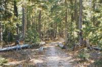
It was a warm night but a cooler day. Were wandering through pine and spruce forest at about 8,000-9,000'. The maps lied about the trail, which doesnt follow the Divide, but instead follows jeep roads, with only about a mile and a half of foot trail north of John Kerr Peak. The route was well marked, but since it winds in and out of the many drainages, there was a lot of extra distance not shown on the map. There are a lot of hunters out this morning. Weve seen four vehicles so far, and only one deer.
LATER: We saw five more deer this afternoon, and several more hunters. We followed rough foot trail for about six miles south of John Kerr Peak. It was a real roller coaster walk, with a lot of climbing up and down through grey briar bushes over loose volcanic rock. I was very slow. Two full days off, plus a heavy load, makes it much harder to do the climbs, plus I think walking on roads so much has spoiled us. Were not used to having to watch every step.
Jim: We came off the ridge to get water, and even then the spring was little more than a seep. We had to work to get that water. It was almost dark by that time so we kept going along the road and made camp less than 50 yards off the road in one of the few flat spots in the canyon. We were highly visible from the road, but we had no choice there was nowhere else to go.
Monday, November 15 - 23 miles to campsite near Negrito Fire Base (Elev gain/loss: +1610/-1580)
It was a quiet easy morning, following dirt roads again. This is neither the official route, nor Jim Wolfs route, but our own, chosen in the interest of speed and water availability. As far as we can tell from the maps, the official CDT has no water at all, and JWs route would have required climbing 500' back up the hill from the spring last night and a lot more rough travel over an area that was burned last year in a controlled burn that got out of control. We know theres water on this route, while Jim Wolfs suggested route is more uncertain.
It was really cold last night and this morning. Water bottles, boots and toes were frozen. It has warmed up since, and the long trek through open grassy Collins Park was dry and dusty. Climbing Eichenberger Hill, after a side trip to fill up our water bottles at Turkey Spring, was really hot. Ah, life in New Mexico. This still isnt desert though. Weve mostly been walking though ponderosa pines and scrub grasslands. We havent seen any animals except a hawk that reappeared four times (or maybe it was four hawks?) We got water for the evening at the Negrito Fire Base and decided to camp nearby. It was an easy day, but hard on the feet. Sonic booms provided some unwelcome excitement. I looked around the first time, expecting to see a bomb or other explosion -- a volcano at the least. Then I heard the airplane overhead. Grrr. That wasnt a welcome sound. We crossed the official CDT several times, according to the map, but saw no sign of the trail on the ground. Im not sure it was even built through here. There was certainly no sign of footway or trail signs. Of course, it is always possible the maps lied.
Jim: Surprise there was a pay phone at the entrance to the Negrito Fire Base. So after we got water, we stopped to call Campmor to order another filter element for the water filter. Then we walked less than a mile, went up the hill and camped on the ridge in sight of the Fire Base. The Fire Base is the barracks and training facility for a group of NM forest fire fighters.
Tuesday, November 16 23 miles to Willow Mountain (Elev gain/loss: +3130/-1000)
We went to sleep listening to a large owl overhead and woke to a chorus of coyotes. One sounded more like a wolf than a coyote.
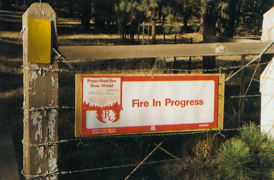
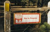
The crew from the fire base passed us early on. Soon afterwards we saw a sign, Fire in Progress. Sure enough, we were walking through a controlled burn area. We saw five hot spots, but no Hot Shots. I dont know where the fire crew was, probably starting more fires. We were buzzed by a German fighter plane. The Albuquerque paper mentioned that the Luftwaffe trains in New Mexico, taking advantage of the sunshine. It was a bit scary to hear a plane right behind us and watch it pass only 50' overhead.
There is blue spruce and moss on the trees in the canyon. Little water is to be seen though, just a few puddles in a couple of the creeks. A lot of the land the past few days has looked a lot like Wyoming and Montana with big open grasslands. The rest is forest. It is pretty, but not what I expected in New Mexico.
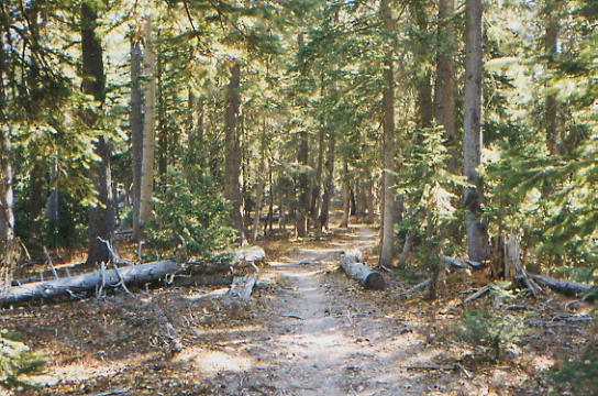
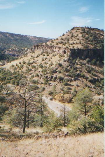
We got in late again: 6:00 and it is already getting dark. (We never changed our watches at the end of October. Its bad enough going to bed at 7:00, 6:00 would be ridiculous.) We couldnt find a flat spot to set up after we got water from Bead Spring until we reached the saddle beyond Willow Mountain. Were finally in the Gila Wilderness. The trails look good, well maintained so far. We were a bit unsure of our route, since trail # 138 only showed on one of the three maps as connecting Willow Creek Campground to the trail to Mogollon Baldy. A friend told us about this route, so we hoped it would be open, but didnt know for sure. We had hoped to ask for information at the campground or ranger station at Willow Creek, but they were already closed for the season. We had to pass through a private development for two miles, past a lot of no trespassing signs, but eventually we reached an official Forest Service trailhead. That was a relief. There are a lot of possible routes through the Gila. We wanted to see as much of the Wilderness as possible, and explore the Cliff Dwellings, so we put together a hodgepodge of trails to get us through, based on a mix of other hikers routes and recommendations. We then reexamine the options whenever we reach an alternate route. Its an interesting way to hike. Theres a freedom to it, but its not as easy as simply following the blazed way.
Jim: After a long road-walk, we finally got back on footpath. After we passed Willow Creek Campground (which had the water shut off) and walked a few miles to the end of the road, we found trail and started climbing. We found the spring near the top of the ridge and filled up and thats when Ginny hurt her neck. Probably pulled a muscle, but it scared both of us and made it difficult for her to carry the pack. We only went a couple more miles after that, but once we got up to the ridge the trail was really good - flat, easy walking. We camped in a saddle in the middle of the blowdowns.
Wednesday, November 17 - 18 miles to White Creek Flats (Elev gain/loss: +3150/-5400)
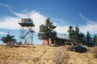
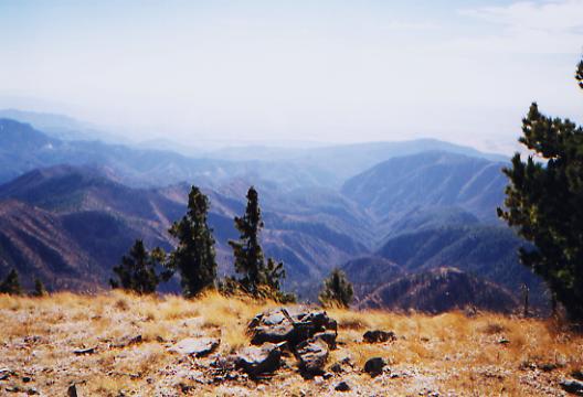
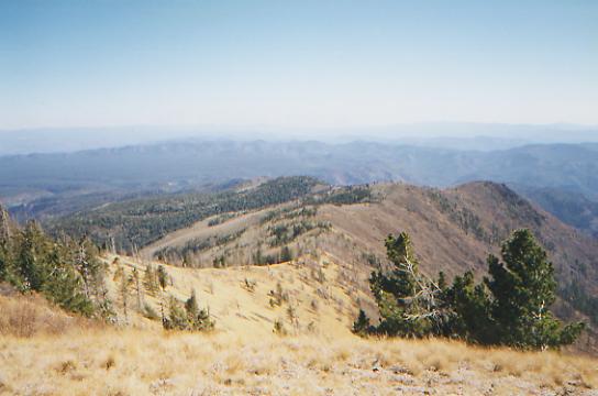
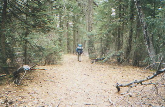
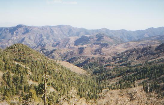
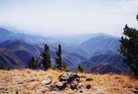
We had lunch on top of Mogollon Baldy, at the first fire-tower weve passed on this trip. The view is stupendous, though it is a rather hazy day. A front seems to be blowing though. Its cold and windy with a light layer of cirrus on the horizon. The climb up wasnt difficult, though a mile or two of the trail was badly burned. It is so odd, but nice, to be on groomed trail with signs at all the junctions, and even at the springs! The trees here are enormous old Douglas Fir and Ponderosa Pines. One of the ancient forests, I think.
LATER: The burned forest continued for the next ten miles. Its pretty depressing to see the devastation, and the blowdowns were really bad in spots, but the descent was very gentle and easy. There was a grassy area, Snow Park, that reminded me strongly of Montana, and the ferny woods were reminiscent of northern Pennsylvania. It wasnt a hard day, only 3150' in climbing (but 5400' down), but it was long. Trail walking is much slower than roadwalking, even when it is easy. The river walking will be slower still. Jim thinks well make it to the Cliff Dwellings tomorrow, but Im a bit doubtful. I know what Im like crossing streams. (Cautious!) We have enough food to wait a day, if necessary. Well see how we do with sand, gravel, and dozens of river crossings.
Jim: Ive gotten used to the road-walks, but the burned-over forest is still depressing. I probably will never get used to that.
Thursday, November 18 - 17 miles to the West Fork of the Gila (Elev gain/loss: +1800/-3650)

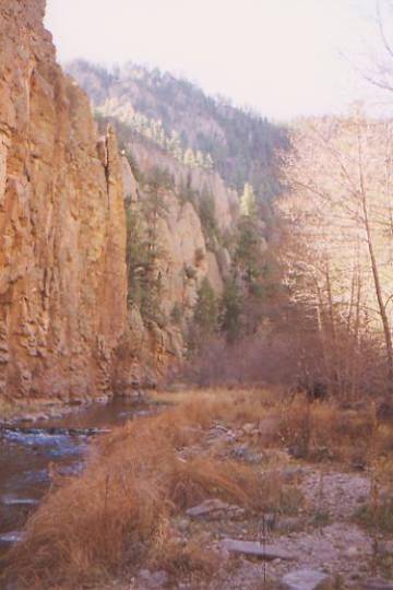
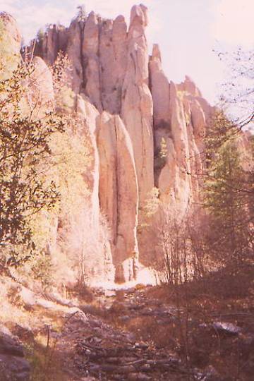
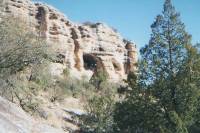
Were drying out in the sun by the river, eating lunch. Overall, the trail has been better than I expected, with long stretches of sidehill above the river. We managed dry crossings for the first eight, number nine got our feet wet, and number eleven got me wet all over. Just standing on smooth rock, I started to slide and ended up lying sideways in the river, wet from shoulder to toe. Fortunately, it is fairly warm in the sun as long as the wind isnt blowing. I should dry pretty quickly. The canyon is very spectacular, with cliffs, spires and caves. A few trees still hold their brown and gold leaves. The pine areas are mostly burned, but some of the flat sections would make nice campsites. A few flowers are still blooming; I saw harebell and fire rocket gilia. They go with the many bees and butterflies that still flutter about, the last remnants of summer. We saw four elk when we started out this morning, and were woken up by an odd bird call, maybe a heron? We saw a great blue heron yesterday.

LATER: The river got Jim too, twice, on crossings 41 and 59. By about # 44 we stopped playing the game of trying to cross without getting our feet wet. We were tired and the river was getting wider and deeper. It was easier to just splash through rather than try to balance on rocks. By about number fifty, my toes were numb. Thank God it was a warm day. We finally stopped for the night at 6:00 p.m., at the junction with the Meadows Trail. It felt like much longer than 17 miles, but that may have just been because we were slowed by the crossings. We saw a couple of deer, but we made so much noise rustling through the leaves, everything else was scared away. Yesterday it was aspen leaves, then oak; today there were sycamore leaves crunching underfoot.
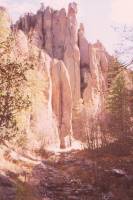
The cliffs and spires continued all afternoon. We saw one cliff dwelling in a small cave high above the river, next to an enormous cave in the cliff wall. We knew it was there, and had been looking for it, but when we did see it we got upset because it meant we were about two miles from where we thought we were. Oh well. Jims second fall was a bad one. He hit his knee hard on a rock, plus he was already cold and wet and it was late in the day. He was not a happy hiker. Tonight is another night for eating dinner by the light of the moon. Fortunately, it is pretty warm. There was a very nice, very pink sunset.
Jim: There were lots of campsites along the river, but we kept moving until dark, trying to get to the last of the crossings before we ran out of daylight. We didnt make it, but we did find a reasonably nice campsite. It was really long past time to stop because we were both very wet and cold. Wet clothes dont dry when youre hiking in shadow, and we spent most of the day down in the canyon.
Friday, November 19 - 9 miles to Gila Hot Springs (Elev gain/loss: +1060/-1380)
Today was a funny drifting sort of day. We had no real plan; we just played it by ear. First we discovered that our wet boots had frozen solid. Last night was warm enough we didnt think to put them inside the tent. This morning they were totally encased in ice. When the sun reached our campsite, we begin chipping the ice off the boots. Not recommended treatment for leather, Im sure. We knew there were two more stream crossings to do, so we put on our sandals and started to hike, carrying our frozen boots around our necks. That water was cold! When we tried to put our boots on, they were still frozen stiff. It took a mile of hiking in the sun before they thawed enough to be bearable. Its odd to be worried about frostbite here in sunny New Mexico!
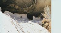
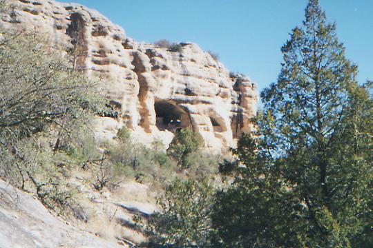
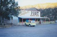
Two miles up the trail, we reached the Gila Cliff Dwellings, Mogollan ruins dating back to about 1280 A.D. Like a lot of the cliff dwellings, these were only inhabited for a few years, (about 20 years), then abruptly abandoned. There were six caves. We could enter most of the ruins, though a few we only looked at from outside. They had guidebooks, but we had no change, so we had to skip learning the details of what they know (or think they know) about the Mogollan people. Maybe next time. It wasnt as spectacular as Mesa Verde, but it was interesting, and not nearly as crowded. There was only one other couple there. A ranger offered us a cup of hot coffee, which I gratefully accepted. A dayhiker offered us salad and granola bars when he heard Jim mention to the rangers that we were out of food. We accepted that too. We then walked two miles up the road to the Visitors Center, where we were happy to find our maildrop waiting for us. A couple from Tucson offered to cart off our trash, since there is no garbage service in the park. We were very happy to hand over the empty box and the trash from the past week.
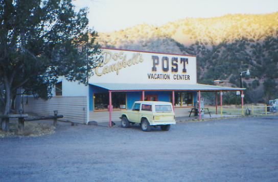
Then we headed down the road to the community of Gila Hot Springs, population 22. We were very happy to see that Doc Campbells Trading Post was open. It was 2:30 by that time and we were starving, so we ate microwave hamburgers, homemade ice cream, sodas, chips and cupcakes. Then we took a very hot shower, talked on the phone a while, ate another burger and juice and ice cream, and finally left about 4:45. We planned to go on to the campground, but a sign at the road said, Wilderness Lodge, breakfast included, $45/couple. We decided to see if they had a room, despite the fact that it was a Friday night. They had several guests, but they did have a room available. They also had a hot spring in their front yard. We have seen a lot of hot springs out here, more than I expected, as well as private hot tubs. Next time, Im bringing a bathing suit.
Jim: What a day!! We started by chipping ¼ inch of ice off our frozen boots and ended it sleeping in a bed after spending the afternoon hanging out at the store demonstrating the meaning of feeding frenzy to the owner. Neither of us have ever been attracted to microwave hamburgers before this time we went back for seconds. Weird.
Saturday, November 20 - 15 miles to Middle Mesa (Elev gain/loss: +3420/-1530)

Today turned out to be tougher than expected, with a lot of uncertainty as to whether or not we were on the trail. We got a late start after a leisurely breakfast of homemade bread, muffins, cereal, juice, etc. Its the second bed and breakfast weve stayed in that served only cold meals. Abundant, and much easier to prepare, especially for a crowd. Dean, the host, told us that the trail we were looking for wasnt as shown on the map. Evidently the trail used to go through private property, and the ranchers didnt want hikers wandering by so they rerouted it. They didnt bother to put up any signs though, so we followed a pack trail up a ridge, then steeply down, then along the East Fork of the Gila to a place where a family was living in a shack made of boulders covered by a big tarp, then back up to the mesa above, all without knowing whether we were on official trail or just some local hunters path. The trail atop the mesa was pretty obscure, disappearing frequently in deep grass, but its location matched that of the trail we were seeking, so we followed it for a couple of miles, then headed cross-country to pick up another trail across Middle Mesa. There were a lot of cross-wise canyons that didnt show on the map, but eventually we found good trail heading in the right direction.
We spoke to the family living in the tarp shack, asking about the trail. There were four or five children and their parents. I asked if they had lived there long, and she said, Oh, we dont live here. But the woman had met Jeff Wheatley when he passed through about ten days ago. Evidently, he was lost and looking for the trail, and she directed him back to it. Unfortunately, she probably directed him the wrong way, since she tried to steer us back the way we had come. They havent lived there long, I think, and may not have maps, since it took a while to clarify where we were trying to go. Once I did, though, she showed us the hidden path up to the mesa. I do wonder what their story was. They looked like squatters, but they were on private land, not National Forest. On the other hand, their shelter was pretty well hidden, unless you were looking for the trail up the mesa, and it doesnt seem to get much use. Probably because no one can find the trailhead. Another of lifes unanswered questions.
There were nice views in all directions and we passed through several life zones--desert, scrub grassland and ponderosa pine--so it was interesting walking. Jim saw three deer. We also saw a small tarantula. The only water, once we left the river bottom, was in some pretty disgusting stock ponds. The dinner water is not a pretty sight. Its a good thing its dark and we cant see what were eating. The open mesa was flat, but the grass is very lumpy, so we kept going on and on and on, looking for an area with big trees and a flat spot to set up camp . Jim had to carry the water for three miles before we found a spot, right near a gravel road.
I was in a fairly grumpy mood for a while. Too little sleep last night, combined with the uncertainty about the trail made me a bit testy. Are we on Trail 708, 709, or some unknown local trail? Where did the trail disappear to? Should we stay on this trail, or try to shortcut cross-country to the other one? Too many questions. This is big country, with a lot of wilderness. While we were never really lost, it wouldnt be difficult to get lost here.
Later on, when we were walking along the mesa on good trail, I was feeling happy again, and very grateful for all the good that is my life. So I said a long pre-Thanksgiving thanksgiving prayer.
Jim: We spent most of the day with uncertainty, but we ended almost where we wanted to be. We really wanted to be a mile or so down the road that we camped next to, but we ended up cooking dinner in the dark so we werent gonna make another couple miles. We both gave thanks that we couldnt see the color of the water that we were using for dinner. We boiled it for a long time.
Sunday, November 21 16 miles to just beyond Reeds Peak (Elev gain/loss: +5150/-3090)

We had another late start. When its cold in the morning, it is hard to get motivated to leave the warm sleeping bag, so we dont. We walked about a mile and a half on gravel road to the trailhead for the Black Canyon Trail. It is a pretty walk, climbing gently along a creek toward the Divide. First it was a wide river-bottom trail, with lots of cottonwoods and sycamores, then about four and a half miles up, the trail narrowed and we began a series of short shallow stream crossings. Weve seen a lot of tracks, but no wildlife. There are interesting rock formations and spires along the way. It was a good choice.
Then we left the canyon and tried a side trail up to the Divide. That was a bad trail, fire damaged, with lots of deadfall, and steep nasty climbs on rocky eroded trail. We climbed Reeds Peak through a lot of blowdowns. There was a beautiful view from the top looking south and east. We climbed part way up the fire-tower, but it was very cold and windy, so I got nervous and we went down fairly quickly. It is still cold. We packed up dinner and moved into the tent to eat. Were dry camping on a burnt saddle, since we missed the trail to Squeaky Spring under all the downed trees. It is still a mile or so to Willow Spring, so well have no hot chocolate tonight. At least we managed to find a flat spot that isnt directly under any dead trees. On the way down Reeds Peak, the steep terrain was a bit unsettling. All the dead standing trees didnt help. The wind doesnt whistle through a burnt forest, it screams.
Jim: The morning was down into the canyon, then back up to the ridge. The trail to Squeaky Spring was buried in blowdowns and we never even saw it. We found the south end of the access trail for it, but werent so desperate for water that we needed to backtrack a couple miles.
Monday, November 22 - 17 miles to Gallinas Canyon (Elev gain/loss: +2740/-4340)
Winter has arrived in New Mexico. We woke in the night to the unwelcome sound of snow slithering down the tent. It didnt snow long, just a light dusting, but it was a sign of things to come. The wind has been blowing fiercely. Fortunately most of the trail has been on the eastern side of the ridge, out of the wind. But the clouds come and go. Weve had a couple of snow flurries, some sun, and both at the same time. The trail has been intermittently very bad, with burnt zones, lots of deadfall and briars. Some sections are nice walking though old growth forest with enormous trees.
Water was a problem. Both Willow Spring and Mimbres Lake were frozen solid. Finally we were able to crack the ice on the stone horse trough at the McKnight Cabin, about half a mile off trail. We were getting worried, as that is the last water for several miles and we were almost out.
The trail improved as we followed old logging roads along the crest of the Black Range. There was no more fire damage, which was a relief. I understand now why the Forest Service is so quick to close the forest during drought years. They almost did it again in the Gila this spring, but there was a big storm in late April that brought much needed water to the mountains. There have been a lot of bad burns all through the wilderness. I had no idea how bad it was.
We took a side route down Gallinas Canyon in search of water instead of staying on the ridge down to Emory Pass as planned. Gallinas is a narrow little canyon, fairly steep in spots. It is much warmer down here than up on the ridge. Less windy, I suppose. The creek is intermittent, with some pools and running water but lots of dry stretches too. Finding a flat spot to camp wasnt easy since the canyon is so narrow, but we made it before dark this time.
Although the afternoon improved (both weather and trail), it was still a bit disappointing. There were some very beautiful views, especially to the east, but the whole section was quite a bit longer than we expected. With the bitter cold, adding miles wasnt welcome. We wanted to lose altitude in the hope that it would be a few degrees warmer. Its not much, but it helps. I think the desert will be a very welcome change.
Jim: This was one of those decisions should we stay on the ridge (and the trail) and maybe find water or drop off the ridge on an alternate trail to find more certain water and then have to climb back to the ridge (and the trail) on the other side of the pass. There are positives and negatives both ways. Thats one of the things we love about this trail were always being presented with choices and we get to live with the results of the choices we make. Weve found that the choices weve made have almost always been the right ones for us.
Tuesday, November 23 - 16 miles (Elev gain/loss: +2130/-3570)
Another late start, thanks to the cold. Its hard to leave our warm sleeping bags when its in the teens outside. Then we took a long break at a camping area near the road as we made the final decision on our route to Deming. Well stay on the west side of the Mimbres Range, following dirt roads. We had planned to follow the ridge south of Emory Pass as far as we could, then head down the east side and do a cross-country route into the Cooke Range, but with the cold and the holiday, Im not in the mood. I want to celebrate Thanksgiving in town. The trouble with the east-side route is that you have to cross private property, but Im not sure where. We have the USGS map for this section, not the BLM map which shows which lands are private and which are public. Weve seen a lot of no trespassing signs in New Mexico, and Id rather not deal with irate landowners. Besides, we are both ready for heated rooms, hot showers, clean clothes and lots of food. Of course, the downside to the west-side route is that it is mostly road walking, but at this point, that really doesnt matter any more.
Anyhow, the morning was a bit rough as we finished descending Gallinas Canyon and began the ascent on the other side. The trail was very rough semi-bushwhacking up a creek for about two miles. The trail isnt shown correctly on the map (surprise, surprise!) so we didnt know what to expect. Then we reached a dirt road and began winding our way south. It was a nice hike as we descended from ponderosa pines to junipers and cactus. We followed a stream for a while that was still iced over at 3:00 p.m. We passed a couple of derelict cabins, then we left the Gila National Forest and began running into inhabited properties. Its all private property from here on. We stopped to chat with one man along the road. Hes a sailor and kayaker. He gave us water, which was really welcome since the next windmill was broken. We ended up camped (illegally) on a hill with nice views. The kayaker told us not to worry if we got caught. He knows the landowner, and she wouldnt mind, but we werent sure that her caretaker would be as open minded. We could see Cooks Peak and the Tres Hermanas as we walked. Cooks Peak towers above the rest of the range, and the Three Sisters are unmistakable. They also mark the end of our journey. Cooks Peak is just north of Deming, and the Tres Hermanas are near Columbus. It was so strange to have the end of the journey literally in sight. Scary.
Jim: We dropped out of the mountains today and were back in juniper and piñon country. Were also back in private land. Its still a few days away, but we can also literally see the end of the trail. The border is just on the other side of Tres Hermanas. Im having mixed feelings about that.
Wednesday, November 24 - 25 miles (Elev gain/loss: +2300/-2770)
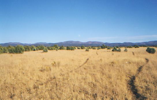
We decided to push to make Deming for Thanksgiving. With the roadwalking, that wasnt hard. We followed a paved highway along the Mimbres River for several miles. It was easy and much nicer than expected. The cottonwood trees are still yellow, and we passed a couple of orchards, some green farms and ranches. The small community of Faywood/Dwyer was a disappointment. We hoped for a cafe or store, but settled for eating our lunch on the bench outside the Post Office. The postmistress let us get water at her house down the road, as did another woman we met along the road earlier. There were windmills and the river, so we would have been all right for water in any case, but we really appreciated the offers. There is always the hope that piped water is better, though you never know. The mountains and hills were really pretty, from grassy Mt. Taylor (not the one near Grants), to round flat Table Mountain, to volcanic ridges, to the Cook Range. The desert showed a lot of variety too, with patches of cholla, ocotillo, yuccas, creosote and mesquite, as well as willows (trees, not bushes!) and cottonwoods along the river. Its not all mixed together like the desert near Tucson. Mostly we saw grasslands with patches of different vegetation scattered about. Over here yuccas, over there ocotillo, but not both at once. We saw our first buffalo finally - but not a wild one. It was in a corral with a cow and a couple of frisky horses. Once we left the highway and rounded Mt. Taylor we could see for fifty miles: to the Florida Mountains, the Hatchet Mountains, the Cook Range and the Tres Hermanas. Miles of desert and isolated mountains. Very pretty. There were only a few scattered ranches here and there, with miles of open desert between.
Jim: Hmmm the river is NOT a good water source a number of old mines are up in the hills and some of the runoff still feeds into the river. I was warned about that yesterday.
Thursday, November 25 - 17 miles to Deming (Elev gain/loss: +1000/-1250)
We made it to Deming by early afternoon, after an easy day walking roads across the desert. We camped last night in a dry arroyo, serenaded by our friends the coyotes. It was very cold, but the sunset and sunrise were nice. We had about four miles of dirt roads, then we headed up the highway past Black Mountain and Red Mountain to town. It wasnt a bad walk, despite being paved, and we moved fast. The hardest part was finding a place to go to the bathroom. Finally we passed a large farm with a thick bamboo fence that sheltered me from the passing cars. Like most western towns weve visited, Deming has no real outskirts. We hoped for a gas station or cafe on the way, but we only passed a couple of houses and farms. We saw a roadrunner, several hawks and jackrabbits, but no other wildlife. Most businesses were closed for the holiday, but we managed to do laundry at the mini-mart before they closed, find a room at the Butterfield Stage Motel, and eat a turkey dinner (with two desserts) at Dennys. Were warm and clean and happy again.
While Ill be sad for this adventure to end, Ill also be glad to be back in the world of heated rooms and clean clothes. One of the hardest parts of this trip for me has been dealing with the cold. Its not just the difficulty of leaving the tent in the morning to fire up the stove, its also not being able to clean up because the water is icy, the pain of feeling warmth return to frozen fingers and toes, having to take short breaks because we get cold so fast, and feeling the icy envelope of air surrounding my sleeping bag, sneaking in every time I move. After months of use, my 10* bag is only warm to about 30* and most nights lately have been well below that. The days are in the 40's, sunny but cold. The good part is that walking is easier when its cool and we drink a lot less. I love snuggling with Jim on cold mornings and warming my hands on a hot cup of cocoa or oatmeal. Summer was so short, only about six weeks, the rest has been a cold weather trip. Weve been lucky to have so little rain and snow. I love the sunny days, but the cold nights are hard to handle. Being warm is not something to take for granted, any more than being clean, or well fed, or even having enough to drink Theyre blessings. Its easy to forget that when life is easier. At its most basic, nothing can be taken for granted.
Home | Links| Trail Journals |
The Thruhiking Papers | Bun-bunMontana | Wyoming | Colorado | New Mexico
Created: Fri, 16 Jan 2004
Revised: 30 Sept 2016Copyright © 1999-2017 Spirit Eagle