|
 |
 |
 |
 |
|
|
|
|
|
|
November 1-3 - rest days in Grants - 11 miles (Elev gain/loss: +1300/-300)
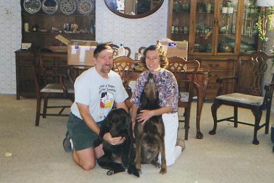
We had a longer stay in Grants than we intended. Tom and Donna Bombaci are two terrific trail angels who run an informal hiker hostel about 10 miles outside town. Donna is a doctor at the local prison. Tom has done a lot of work scouting CDT routes in the area. They have a nice house with a terrific view out their sunroom to the valley below and two beautiful friendly chocolate labs, Sassy and Lizzie. On Monday, Tom loaned us his car to do errands and eat lunch at Pizza Hut, then we relaxed all afternoon. The next day he dropped us in town where we ate breakfast at the Uranium cafe, then walked the ten miles from town back to Toms house to finish the section. Jim wasnt very interested in breakfast, which is really not like him. It took about an hour and a half for him to force down some french toast. As we walked, he got sicker and sicker, barely making it back to the house. It seems to be food poisoning, and he was really sick, unable to hold on to any food or water. The next day he was a bit better, but still unable to do any serious hiking. Tom and Donna were absolutely terrific, offering to let us stay as long as it took for Jim to feel better. About 5:00 p.m., a call came from the Post Office, more hikers were in town, could they stay at Toms? It turned out to be Jason and Julian. Tom went to pick them up, as well as some Chinese food for dinner. We spent the evening talking trail. It was really nice to spend time with other thruhikers.
Thursday, November 4 - 17 miles to Bonito Canyon (Elev gain/loss: +1660/-670)
We finally made it out of town at 11:30 a.m., after a very leisurely breakfast with Tom, Jason and Julian. Our stomachs are still acting up, but not enough to stop us, just slow us down. We were so lucky to be at Toms when the stomach bug/food poisoning hit Jim. It would not have been good to get sick out on the trail. (NB: Jason and another thruhiker both got sick one day out of Grants. Pizza Hut may have been the problem, since that was the only thing all had in common. Of course, it could have been one of the springs north of town.)
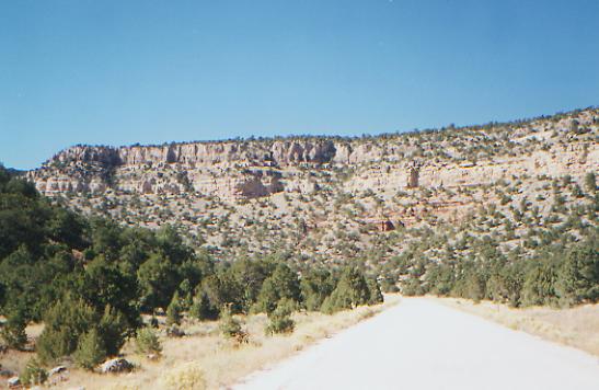
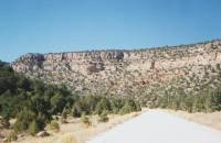
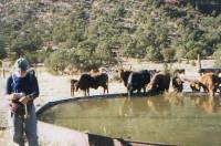
The walk out of town was easy, following roads past houses and trailers for about two miles, then into beautiful Zuni Canyon. Its narrow with yellow and red sandstone cliffs on either side. We got water at a big stock tank near the road junction about ten miles out of town. The cows were not happy with us, since it was time for their afternoon watering. From there, we turned into Bonita Canyon, which is more open, with ponderosa pines and lots of juniper and piñon pines. The first windmill, where we hoped to camp, was dry. It was still spinning, but no water was coming out. We werent desperate, but decided to continue to the next well anyway. Fortunately, it had water and trees nearby that made a good campsite. We saw our first big lava flow at the junction of the two canyons. Its hard to imagine walking on that, but tomorrow we will be doing the Zuni-Acoma Trail across seven or eight miles of lava. I dont think my feet will enjoy that.
Jim: We wandered into Tom and Donnas late Sunday afternoon. There was some doubt that wed make it and in fact, when we passed a spring a couple miles before getting to the road, I was almost ready to camp there. Tom and Donna were just about to have dinner when we got there, but they rustled around and found enough food to share with us, then pointed us to the shower, the laundry facilities and a bed. Just what we needed. Thank you.
Monday was a day for errands feeding, Post Office, eating, shopping, eating, laundry, eating, cleaning up the gear, eating, repacking, eating .ad nauseum. Literally. One of the problems Ive had on the trail is weight loss. The cure is simple eat until Im sick, and then force-feed some more and more until we leave town and I spend the next 24 hours wondering if my stomach will ever recover. It does, but its not a pleasant experience. Ive gotten to the point of hating to go into town. But its a necessity I climbed on a scale back in Colorado and weighed in at 10# less than I weighed when I graduated from high school. And thats not good. So Ill eat my way through this trail like I did on the AT.
Tuesday was another wonderful experience for the first time I didnt have to worry about overeating and making myself sick because I got very, very sick and couldnt keep ANYTHING down for about 36 hours. After breakfast in town and a miserable walk back to the house, I spent the rest of Tuesday either in bed in an upstairs bedroom or worshipping the great god John. The funniest part of the whole thing though, was the dog. Sassy is obviously not accustomed to anyone being in bed during the day. Shed come bouncing through the door every couple hours and wake me up by jumping on the bed and on my stomach. Yeah thats the same stomach that insisted on feeding everything I ate or drank to the great god John. The first time was a surprise after that it was obvious that she was worried about me, and was coming in to check on me. It got to be really funny, in spite of what it did to my stomach. Wednesday was pretty much a repeat of Tuesday, although I didnt spend as much time hugging the porcelain throne and I finally managed to keep some food down. So we left on Thursday after talking to Tom about the trail route south of Grants. The route Tom recommended was the same route that the NPS ranger had recommended. Tom and Donna are really nice people, really good friends and really great Trail Angels.
Forgot to mention that on the walk back to the house on Tuesday we stopped at the BLM Station in Grants and talked to them about the route south. The rangers told us a few more details about how bad the official trail is and disavowed any responsibility for it. They recommended an alternate route the same route that Tom later showed us on the maps. Forty waterless miles across the Malpais isnt trail its idiocy.
We left town late (after a good breakfast at the Uranium Café) and started the 10+ mile roadwalk out Zuni Canyon to a stock tank near the entrance to Bonita Canyon. We shared the water with a herd of cattle although I doubt if the cattle appreciated the sharing anymore than we did. Its amazing how casual weve become about the cattle.
Friday, November 5 - 17 miles to La Ventana (Elev gain/loss: +1080/-1500)

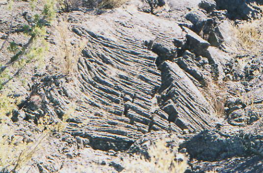
We are having lunch in the badlands of the Malpais. It doesnt look as Id expected. While there is a lot of chunky lava, there are also trees and grasses, mostly ponderosa pines and junipers. The lava isnt continuous. We get breaks when we walk through grass, but it can be pretty rough. The sign at the trailhead warns that it can take 6-7 hours to walk the 7.5 miles. I hope not. In some ways it reminds me of walking the rocks in Pennsylvania. The trail is interesting for a lot of reasons. The lava is actually five different lava flows, the latest only about 1000 years old. The trail is an ancient Indian trail between Zuni Pueblo and Acoma Pueblo. If you go the other direction, it is called the Acoma-Zuni Trail instead of the Zuni-Acoma Trail. Some of the posts along the trail say, Escalante Trail, a previous incarnation I guess. I dont imagine the Spanish used this trail much, as it would be really hard for horses to walk on the rough rocks. It is fun to hike past cairns built 700 or more years ago. The cracks and crevasses are fun to jump, though the lava really does tear up our feet and twist the ankles.
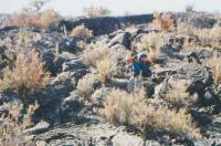
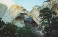
LATER: The walk across the lava took longer than expected. It got very wearing after a while, both physically and emotionally. It was also a day of minor disasters. The camera broke, then Jims glasses (now held together with a safety pin, like my dark glasses) and the filter is acting up. Thanks to Jims persistent scouting, we found water in a stock pond behind the dry well near Los Pilares. Darwin at the BLM had told us there was water there, near the big rock formations, but it wasnt obvious. We had a pretty walk along the highway past some big stone rock formations and sandstone cliffs. There were lots of caves. Just before dark we made it to La Ventana, a beautiful big natural arch. We looked for a place to stop before the arch, but the fences along the road were too new and had no openings. The land on one side of the road belongs to the Malpais National Monument; on the other it belongs to Acoma Pueblo. Neither was very hospitable. I doubt were supposed to camp here at the Arch, though there are no signs saying we cant, and it was the first place away from the road for two miles. It is a warm enough evening that we can sit out and watch the stars appear. We saw one meteorite. Its nice not to be huddled in our sleeping bags the minute we stop walking.
Jim: Not one of my better days everything seems to be falling apart. And crossing the Zuni-Acoma Trail took almost forever. Its supposed to be seven miles, but its not. Its more like nine or ten. We found the water at Los Pilares, a big rock formation, by following power lines up the ridge. Once I got up there I could see the houses that the power lines led to as well as a dry stock pond down below. But behind Los Pilares, there was a lovely, brown-green, seldom used and very wet stock pond. Not the worst water source weve used. Once again we found a desperation campsite just at dusk. This one didnt have water, but it did have an outhouse, which seems to be the local outhouse of choice nearly every car that went by La Ventana stopped to use it.
Saturday, November 6 - 21 miles to Armijo Canyon (Elev gain/loss: +3480/-2860)
The morning was an easy and interesting one. On one side, we had the lava flows in the Malpais, on the other, the steep sandstone cliffs of the Narrows. At the camping area at the end of the Narrows, we met a group of kids out for the weekend. Theyre Mennonites, doing a year of volunteer service in Albuquerque after high school. They come from all over the world. One girl was German; the others came from Pennsylvania, Virginia and Indiana. They were nice folks. They offered us pancakes, coffee, fruit and water, all of which we accepted, gratefully. Trail magic strikes again.
Then we continued down the highway through grasslands to the Cebolla Wilderness. We saw a couple of deer this morning. We seem to be in a leisurely mood. Were about half a day behind schedule, and dont care. We know where to find water for the next 15 or so miles, so that isnt a concern. Well follow jeep roads and trails in the Wilderness Area, then county roads into Pie Town tomorrow or Monday. Were in no hurry. Weve lots of food. It feels like a summer Sunday.
LATER: We passed a couple of old cabins today, mostly ruined, though an adobe cabin near Armijo Spring was in fairly good shape. Its not that long since it was abandoned. It is still inhabited by mice. Jim got water from the spring up the hill since the stock pond below, one of at least three weve seen in the past few miles, looks muddy and mucky. Im used to green water a lot of algae grows in the metal stock tanks but brown water is harder to stomach (and harder to filter.) It has been a very quiet and peaceful day, gently climbing Sand Canyon, then switchbacking down into Armijo Canyon on old unused jeep track. We saw two jeeps at lunch, but nothing else except birds and cows. The country is grasslands with junipers and occasional pines, lots of desert broom shedding the last of its seeds, and winterfat still in bloom. The canyons arent that tall, maybe 100 - 200' but the sandstone boulders are pretty.
Jim: Today was mostly roadwalking. We started this hike with a roadwalk in Montana and Dave and I bitched and moaned and groaned about it all day long. Now roadwalks have become just another part of the trail. Most of the roadwalks are on dirt roads or jeep tracks a few of them active, some are semi-active (one or two cars per day), some abandoned. There are worse things in life and in hiking.
The water source for tonight was a springhouse at the top of a draw above an abandoned ranch about a 300 climb. Wouldnt you know it I went looking for the water without taking the water bag with me. So I found it, then had to go back down to get the water bag, climb back up for the water and then haul it down to the bottom of the draw. When I got there, Ginny was waiting at the abandoned adobe shack but didnt want to stay there cause shed seen either a rat or a large mouse in the house. So we moved on another mile or so.
Sunday, November 7 - 21 ½ miles (Elev gain/loss: +2430/-2380)
Its cloudy and breezy, a lot cooler than yesterday, but pleasant for hiking. There was a beautiful red and orange sunrise, nice to wake up to. We lost the trail out of the canyon and ended up bushwhacking easily for a couple of miles out to the gravel road that well be following all day. Its flat open country, sage and juniper. There are occasional views of the Sawtooth Range to the south and the Chain of Craters, a line of small volcanoes, to the west, but mostly its just low hills and grass. The big excitement is looking for windmills and trying to guess whether theyre working. Weve seen four so far today. There were cows at some of the windmills, so the assumption is that theres water around here somewhere. The road is fairly busy for a dirt road, though no one has stopped to ask us if we need help as they have at other times. It may just be that its a nice Sunday afternoon, and people are out enjoying the day.
LATER: A couple of cars did stop to chat, though most didnt even slow down. It was a long afternoon. We did meet a very nice older couple at a house along the road. It was built around 1910 and used to be a trading post. They just bought it and plan to fix the well and get rid of the mice and such. They offered us water, which we were glad to accept as we had planned to get water at their (broken) well, since it was on the map. The Delorme maps show water sources that arent on the BLM maps, but often the wells that are shown are pretty old and no longer work. Still, its better than no information on water at all. We got a gallon of water from the couple, then continued down the road. The next windmill, at a derelict house, was spinning merrily, but had no pump attached. Then we found an electric well, not on the maps. The electricity was turned off, but the power box was open and it was obvious from the mud that the well gets use, so we turned on the power, filled up our water bag, turned off the power and then walked a couple more miles to a campsite under a pinon tree. The pinons are ripe, shedding nuts on us as we sit underneath them. You can eat them raw and they are really good.
Jim: Our campsite is on the only piece of public land for miles in either direction. Its just a little corner of a section at the top of a ridge, just off the road. Again, no water and this time, no outhouse. But its a flat spot in the midst of the juniper and piñon pine.
Monday, November 8 17 miles (Elev gain/loss: +2330/-1940)
Pie Town proved to be a disappointment. There was no grocery, no motel, no shower, no coke machine, and the cafe is closed on Mondays. The local trail angels, known for their kindness to hikers, were not home, either. On the other hand, Blake sent a goody box, which provided a nice lunch, and a very nice woman in a car stopped and gave us blueberry muffins this morning. Since we were really hoping for a shower and a hamburger, we tried to hitch a ride to Quemado, 22 miles west. Unfortunately, no one would stop, so we gave up after two hours and decided to keep hiking. We considered camping at the park in town, but the water was shut off and we were feeling very frustrated. Reserve is only a few days away. We can last till then. The first two wells we passed were on private property. We tried to get permission at the second ranch to get water from their windmill, but no one was home but a couple of dogs and a half dozen loose horses, who nosed our packs curiously. (They probably never smelled anything that bad!) So we got water from a hose and went a little way down the road to set up camp in a pinon grove. The land around here is all private, but there are no houses on this side of the road, just open rangeland. There was an interesting knife-edge ridge just south of town. It was volcanic, I think, but with a pink layer too. There is another range to the east with big volcanic cores, as well as tall Alegres Mountain which we will circle in the morning. There was another pretty sunset.
Jim: This time the campsite was on private land again no water or outhouse, but we got water at the horse ranch. We tried to find someone to ask permission to use the stock tank, but there was no one home. We took water from an outside faucet and walked back to the gate through a crowd the dogs and horses were all curious and they all wanted attention. Wish we could have met the owners. You can learn a lot about people by watching their kids and animals I think wed like these people. Maybe next time.
Tuesday, November 9 - 23 miles to Tio Vinces (Elev gain/loss: +5390/-4960)
We had a late start after a nice rest. We were serenaded by owls, coyotes, elk and roosters, together and separately. Were heading toward the National Forest, still on dirt roads that pass through private ranches. We passed a couple of broken windmills and derelict houses. Were winding though a chain of volcanic cones in pinon and ponderosa pine. The road is quiet; only two cars passed us this morning. It looks like well be in Reserve much sooner than expected. The mileage I was using was for a route we probably wont take that goes all the way in to Reserve. There are so many possible routes through here, it is hard to choose.
Jim: Today we found another water source thats not on the maps its a windmill thats located a couple hundred yards west of the road at a point directly between two of the volcanic cones about 15 miles south of Pie Town. There are two iron gates one on each side of the road. We took a break at the gates and when we stood up, we saw the windmill directly behind where we had been sitting.
The map distance for this route didnt look that long, but the route over Mangas Mountain goes on forever. We finally got to Tio Vinces spring at dusk (surprise, surprise!). Its a USFS horse camp complete with corrals and the water source is the horse troughs (surprise, surprise!). We also had a LOT of traffic go by here on the road. Hunting season has been with us ever since we crossed the Wyoming/Colorado border and its in full swing in New Mexico right now. We stocked up on hunter orange before we left Creede, Colorado.
Wednesday, November 10 - 12 miles to NM 12 to Reserve (Elev gain/loss: +1780/-2520)
We ended up racing darkness last night to the campground at Tio Vinces. I had been told that it was the first good water since Pie Town. Unfortunately, that was true, but not because the water there was that good the spring feeds two algae-covered horse troughs but it was better than the brown and green stock impoundments we had passed earlier. We saw only one working windmill all day, and the water there was also very green. We ended up doing more miles than expected because the road up Mangas Mountain does a lot of twisting and turning that doesnt show on the map. It was a long climb. Todays route does much the same as we wind southwest toward Highway 12. We go up and down over the ridges and round about. We were up in the ponderosa pines but have gradually descended to sage and pinon again. We actually ran into some CDT markers here in the Apache National Forest. They have been sparse in New Mexico. Only in the Malpais, San Pedro Parks and on the Ojitos Trail did we see any CDT markers -- about 25 miles in all. They didnt save us from a wrong turn though, as we followed a road not shown on any of the maps that appeared just where we were supposed to turn. It dead-ended at a small spring after 3/4 mile, so we climbed over the ridge and quickly picked up FR 218 in the next valley. We ran into the campsite of a hunter. He was one of the few successful ones weve met. We didnt tell him about the two or three elk who kept us awake last night bugling next to the campground. (Bertha, where are you? Over here dear. Im lonely tonight. Coming. It was quite a conversation.)
We had an interminable wait for a ride to Reserve. Lots of empty pick-ups passed us, but no one would stop. It was very frustrating. It took two rides and about 3 ½ hours to get to town. We had heard about a motel owner who is very friendly to hikers. Sure enough, Len Milbyer was very friendly and helpful. Weve stayed in better places, but the food is good. We finally got the fat juicy hamburgers weve been dreaming about since Cuba.
Jim: It was an interesting hitch into town we spent a couple hours trying to get a ride from the trailhead. The first ride was a couple with a flatbed truck stacked high with camping equipment, dogs and an ATV. We got to sit on top of their gearholding tight to the ATV to keep from falling off--all the way to Apache Wells where they were turning off to go up to a hunting camp. We bought some Coke at the store then went out and spent another couple of hours trying to get a ride the last 12 miles into Reserve. We were finally picked up by a guy who was going to Silver City to attend a class at the college there.
Thursday, November 11 -- Veterans Day holiday
November 12 - Rest day in Reserve
We had to stay over one day in town because of the holiday (post office was closed) but then chose to stay an extra day because we werent ready to leave yet. Another day of rest with food and drink seemed like a good idea. Although the room is pretty basic, Len and Debbie are really nice and the restaurant they run is good. Pizza and hamburgers, hiker heaven. They have had a really hard time getting established, due to some local resentment of outsiders and environmentalists. (Len was receiving mail from the Sierra Club, which made him suspect.) He offered to drive us back to the trail tomorrow. Thank heaven. Another three hour hitch would not be fun.
It is odd to think that we are only a few weeks from finishing. Neither of is ready for it to end. Despite the difficulties, we are happy out here. Each day is different. There is so much beauty out here, in so many different forms. I am filled with joy at times, and often with a happy serenity. Jim and I are closer than ever. I was worried before we started that too much togetherness could strain our relationship. Yes, we met on the trail, and have hiked (and lived) together happily for the past seven years. This is different, because it has been six months with very little contact with anyone outside the two of us. Twenty-four hours a day, seven days a week, is a lot of togetherness. Fortunately, we like it. We havent gotten bored with each other, or on each others nerves. Instead we remain best friends and loving partners, very aware of how lucky we are to have such a good relationship. Were different, but very well matched.
I wonder sometimes how this hike has changed us, and how it will affect the rest of our lives. It has been a lot more than just a long vacation. The land and the people have touched us both deeply, in ways too profound to understand right now. I know that Salmon and Grants reawoke longings to explore and express my religious beliefs. Meeting true Christians who live their faith is a rare gift, and an important one. Being reminded of how much I dont know about the natural world was also a revelation. The rocks, stars, plants and animals are largely mysteries to me. I have so many questions, so few answers. We walk through this country and only see the surface. I would like to know more. Doing research on grizzlies before the trail was fun, but there is so much more to learn.
Weve gotten glimpses of different ways of life in the small towns along the way, and I am reminded that the lifestyles the media promotes are far from the only ones, or the most desirable ones. Jim and I will never be normal folks, I think. We never were. We chose to give up a middle-class life to go hiking. Now that weve seen the elephant we cant go back, even if we would. There is a Sufi saying, Nothing can go before the presence of God and emerge unchanged. This country is definitely Gods country.
One of the hopes before we started this trek was that we would find a new place to live. We havent seen any place that calls us, despite the beauty. Jobs are very scarce out here. We need a town big enough to offer work and entertainment, along with mountains to play in. Small town living sounds good in the abstract, but if it means taking a job that isnt challenging or interesting, its not worth it. But neither can we live in a city that would require spending half our lives commuting. I have no idea what the future holds for us. But I doubt well be moving to anyplace along the CDT in the next few years.
A part of me wants to return to a more settled life: a home of our own, a chance to become part of a community, friends, church etc. But I would really miss this life: the challenge and adventure, the sense of discovery, exploring the unknown, spending time with Jim, seeing, hearing, touching, and smelling the natural world, etc. Im a bit scared of all the complications involved in starting over. I also am quite sure that it wont be that long before were back on the trail. The PCT awaits. Already it calls us to come explore the high country in California, Washington and Oregon. But a lot of places call us. There is so much world to explore. Our original plan was to do the CDT this year and the PCT next year, but I doubt our feet or our finances would stand another 2600 miles. And it could diminish the impact of this hike to do another so soon. But weve been so happy out here. I really dont want that to end. A second long hike could heighten the effects of this hike. Will we ever be able to go home again?
Jim: Im not gonna get philosophical here I discovered that (for me) the smell of burning piñon pine is really horrible. A lot of people here heat their homes with piñon pine - for that reason alone, I couldnt live here. We tried to get internet access today but when we finally found the library, someone had deleted one of the drivers, so the computer couldnt connect.
Home | Links| Trail Journals |
The Thruhiking Papers | Bun-bunMontana | Wyoming | Colorado | New Mexico
Created: Fri, 16 Jan 2004
Revised: 30 Sept 2016Copyright © 1999-2017 Spirit Eagle