|
 |
 |
 |
 |
|
|
|
|
|
|
Saturday, May 29 - Washington, DC to Butte
On our way, at last. It still seems unreal, even as we sit crammed into tiny airline seats looking out over farms and fields below. This past week has been so hectic, as we finished packing up the house and clearing our desks at work, that the reality of what we are about to undertake has been far from my thoughts. I get glimpses - and my stomach leaps in response - but then thoughts of the future get buried beneath present moment worries.
It was beginning to seem as if we were never going to get out of town, especially when we managed to get trapped in the storage area at 7:30 p.m. Friday night when the automatic gates locked. Fortunately, the managers returned half an hour later and rescued us. We were so tired that the idea of spending the night in the truck wasnt unappealing, but our flight was early and there was still a lot to do at the house. We managed about 3 hours of sleep before the taxi showed up - half an hour early. There was no time to say goodbye to our little house. We just dragged our packs outside, hoping we hadnt forgotten anything important, and drove to the airport in a daze. It wasnt until the plane left the ground that it hit me, Oh my God, we are really going to do it. Were really going to go walk the Divide. I cried happily for a minute, then went back to just feeling exhausted, except for the rhinos waltzing gaily in my stomach. We have waited so long for this. Weve dreamed, planned, written and read about the trail for over three years. We did long practice hikes through Glacier and the San Juans. I know it as well as anyone can who hasnt actually hiked it. But reality will be different, it always is. And reality is that we arent really in good enough shape for this. We have been too busy with work and packing to spend as much time conditioning as we needed. Yes, I know well get our bodies back eventually, but the first couple of weeks of dragging overweight bodies and packs over the mountains will not be easy. Still, I cant wait to start. Tomorrow!
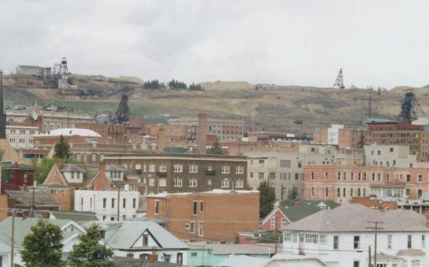
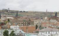
LATER: We met Dave Fleischman, our partner for the first month or so, at the Salt Lake City Airport. Hes an old friend from ALDHA, the Appalachian Long Distance Hikers Association. He has hiked the AT and PCT, but he thought it would be safer to start the trip with other hikers, especially for the areas with serious snow travel and grizzlies. Coming into Butte was really exciting. I felt like a happy two year old looking at the snow-capped mountains below -- scared, but oh so excited. We went out to explore the town after we checked into our motel in the historic district. The owners of the Capri Motel are very nice and agreed to drive us to the trail in the morning. It seems a sad little town. There are some interesting old buildings, but also a lot of empty streets and boarded up businesses. The main activity is out by the freeway near the Walmart. We received lots of friendly waves and hellos as we walked the streets, but it was very quiet for a Saturday afternoon. Even the casinos werent busy. The mine shafts dominate the skyline: tall wooden towers standing out against the sky. We saw the old copper mine from the air, but didnt go up there this afternoon. You can see parts of the mines from town, as well as the 90 foot tall statue of the Virgin in the mountains nearby and snow-capped mountains (the Highland Range, perhaps) to the south. It is a pretty location with hills and mountains all around, but the town seems sad and empty at first glance, except for the friendly people. I am really nervous, but also very happy. It is hard to believe the trek has started. Tomorrow we climb our first mountain. Let the adventure begin!
Jim: The flight to Butte was a welcome respite. Ive had less than 8 hours sleep in the last 4 days and Ginny hasnt gotten much more - were both exhausted. Thats not a good way to start a long distance hike. So in a way it was good to be confined to the airline seat with nothing to do. But I do have a limited tolerance for that kind of inactivity. Butte reminds me of some places in Pennsylvania and West Virginia.
Were in Butte because the plan is to start at Warm Springs, Montana and walk north to the Canadian border, then to return to Warm Springs (appropriately, the site of the Montana State Mental Hospital) and walk south to the Mexican border. The purpose of this "flip flop" was to hike the lower elevation (6,000 8,000 foot) mountains of northern Montana before trying the 7,000 10,000 foot mountains of southern Montana. We considered doing a straight north to south thruhike, beginning at the Canadian border, but high snow levels (160 to 185% of normal) meant that we would have to wait at least two or three more weeks for Glacier to be open to hikers, and we werent willing to wait. The hope is that the snow levels will be better at the lower elevations, and by the time we reach Glacier, the trails should be open, at least to experienced snow travelers.
Dinner at Pizza Hut a typical thruhiker meal followed by the usual night-before-starting-a-hike last minute equipment rechecking and repacking.
Sunday, May 30 15 miles to a Campsite at Champion Pass.
As Dave said, Theres good news and bad news. It stopped raining. It started snowing. We woke up at 6:00 a.m. to a light dusting on the cars in the parking lot and a steady snow falling. Hard to believe its almost June! We were supposed to leave at 8:30, after breakfast at the casino, but Helen, the hotel manager, wasnt comfortable driving the slushy roads. We waited until the snow stopped, then drove 25 miles north to Warm Springs. Its the site of the state mental hospital, an appropriate starting place for a long distance hike.
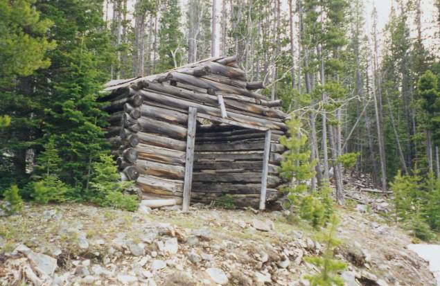
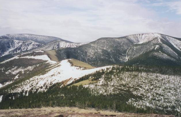
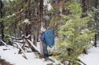
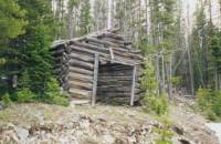
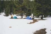
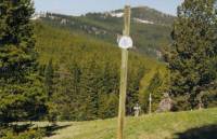
We are starting the trail on the Anaconda Cut-off - a frequently used thruhiker shortcut that goes directly from Anaconda to the Divide at Champion Pass, cutting off about 50 miles of dirt roads that circle around Butte. There wasnt any snow on the ground where we started, so we happily crossed under the highway and followed a stream past a swampy area where we scared up a Great Blue Heron, then climbed up a dirt road past several ranches. We saw lots of cows and fields of clover, brown grassy hills with snowy mountains behind. It was nice easy walking. Our packs are very heavy, but the walking felt almost effortless. We took a very obscure side trail up a draw between two roads. It was fun, though steep. It drizzled occasionally, a mix of light snow and rain, but mostly the day was nice. The sun even came out for almost a minute. We saw our first antelope. I thought it was a whitetail deer at first, but it seemed to just float over the ground. We saw a herd of deer or elk far off in the distance. I really enjoyed walking across the rolling hills. I turned around often to look at the view behind us across the valley. About 3:00 p.m. we reached trees and snowline. There was only about an inch or so on the ground in most places. We knew we were heading for a dry campsite, so we picked up water at a stream next to the road, only to discover that our water filter is broken. Grrr! Dave loaned us his. Later we returned the favor by heating up some water when his little woodburning stove proved balky. We passed several old mines and cabin ruins. One could have served as shelter for the night if we were desperate, though it was very rocky inside. It began to snow again, lightly. We had to cross a couple of fences posted with no trespassing signs when the road we were following to Champion Pass crossed private property. It was probably a mine, but wasnt occupied at this time of year. After climbing a very steep nasty hill on switchbacks, there was no way we were going back down the mountain to pick up another road that would add a couple of extra miles to the day, and, because of the snow, we werent up for bushwhacking through the forest around the property line. Following the road was a lot easier. We had planned to go to Champion Pass for the night since that is where we would meet up with the official CDT for the first time. In fact, we saw our first CDT blaze about ½ mile before the pass. It was a welcome sight. We found a wet snowy campsite near Champion Pass on an old road.
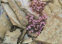
We ran into a ranger at the four-way junction nearby who just started working in this area. She said she has a stack of CDT information on her desk to organize but hasnt had a chance to look at it yet. That gives some idea of the priority of the trail in this district: give it to the person who knows the least about the area. She didnt even know which road we were on. It was a good day for wildlife. We saw two frisky horses, lots of cows, an antelope, a hawk, heron, and lots of other birds like redwing blackbirds, a magpie, larks etc. There was a lot of bird song along the creek. There were also lots of wildflowers. Most were new to me, though I recognized larkspur and yellow glacier lilies, as well as a lone prickly pear, hiding in the grass.
Jim: The office manager at the motel in Butte managed to find us some Coleman fuel. I think she went to Wal-Mart last night - and then she didnt want to charge us for it. In the morning she drove us to Warm Springs and didnt even want to take gas money. Our first Trail Magic. We also had our first bushwhack today - and our first real climb - and our first CDT blaze. A memorable day. The campsite at Champion Pass was really close to the road - and there was a surprising level of traffic during the night. Seems that the road is a short-cut across the mountain. Its also a dry campsite. Would have been better if we could have gone on to the next spring, but it was getting dark and starting to snow when we stopped.
Monday, May 31 -- 11 miles
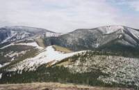
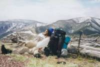
We woke to sunshine, which came and went all morning. We followed tire tracks up a jeep road until they disappeared in a snowy meadow, then we followed orange snowmobile markers through thigh-deep snow. Lots of postholing made slow walking. The snow is melting rapidly, which is both good and bad news. It makes the snow very soft. The views are stupendous: snowy mountains and conifers dusted with fresh snow. We stopped early because the snow travel was becoming very painful. Jims legs are cramping and we all twisted and turned our legs several times while postholing. My stubborn side says to keep going; common sense says to stop. Fortunately I was outvoted. Dave is really good in snow. He led the way all afternoon, which is hard on him. Jim and I were really slow. Partly it is that our greater weights make us sink deeper in snow that Dave floats over.
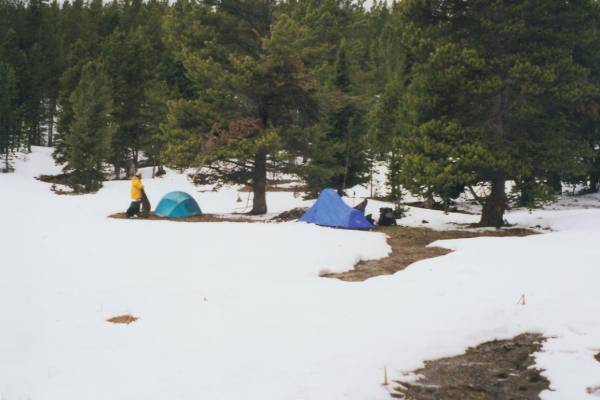
We found a meadow with some semi-dry spots. It isnt exactly flat, but it is better than setting up in the snow. Our meadow is open and windy with a beautiful view of the Highland Range to the south. We saw coyote scat and other droppings in the meadow but no wildlife. The next two days could be repeats of today. Fortunately we have extra food, especially since Jim wont eat when hes really tired. So far weve had little trouble following the route. They did some maintenance here, so even when we turned off the snowmobile trail we could tell where the trail went by the wide path and fresh cuts on the trees. There are no CDT markers though.
Jim: Yesterdays CDT marker was also our last CDT marker. Not bad walking in the morning, but the afternoon brought deep snow, postholing - and a twisted left knee for me. The snow in the pines is beautiful, but not a place to make miles.
Tuesday, June 1 -- 8 miles to campsite near Blackfeet Meadows
We went to bed in a heavy rain, woke to light sleet, which soon passed and turned into intermittent clouds and sunshine. It was a difficult day. We lost the trail, picked up a snowmobile trail, lost that in a pond (not very deep fortunately as I fell through and got wet up to my knees), picked up blazes again but found that they turned in the wrong direction, bushwhacked up a steep snowy mountain (hip deep at every step), found another trail going in the right direction, followed that for a while, then left it when it headed northwest while we wanted to go southeast. We abandoned it for a steep downhill snow-whack. Lunch was in a sunny dry patch near Cottonwood Lake. We all hurt and were tired and feeling pretty glum. I wasnt too upset since I know we have more than enough food to get us through an extra day or two, but the guys are angry at how slow and difficult this is. Jim twisted his knee postholing, which doesnt help.
One problem is that the guidebook and maps totally disagree. The trails we followed arent on the National Forest maps; Jim Wolf uses trail and road numbers from USGS topos that dont correspond at all to the NF maps. Its frustrating. The map shows the CDT following the Divide but supposedly the trail hasnt even been built yet. Trying to follow iffy trail along the Divide seems impossible. Dave has a GPS but it kept giving us conflicting information. The lake is left 0.2 miles, no its right, no its behind us. I think it is less effective in small distances than large ones. And in the large distances, the maps are sufficient.

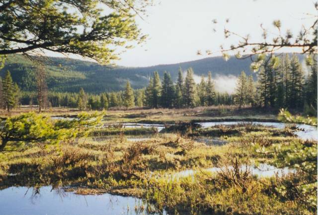
We didnt get very far today, but given the conditions Im not unhappy with it. The day stayed mostly fair except for a light hail shower that passed as soon as we got our raingear out, of course. We finally decided against following the official route up on the Divide in favor of a lower route to Blackfeet Meadows. Its in the right direction, north, but much lower. Finally, a smart choice. The snow eased soon after we crossed the Divide and descended below 7000'. We got two or three miles of clear trail. Parts were pretty steep, but we were so happy to see snow-free trail we didnt mind. We found a lovely campsite next to the stream in a meadow. We can look up at the Divide as we nestle in our fir grove. This is a pretty forest with dense young firs. There are lots of birds singing and we saw a beaver dam upstream. We saw elk tracks but no wildlife. It is so nice to be able to sit outside in the evening and listen to the water and the birds. Its cold but not freezing. Last night I read the first chapter of The Hobbit aloud. That was fun. It was meant to be read aloud, I think.
I am so happy to be out here. Despite the aches and pains, the frustration of dealing with snow and losing the trail, I am content. I revel in each small flower and singing bird, the clouds that build, dark and massive, then pass us by, even the gentle pitter-patter of rain in the tent. I do worry that we are so slow. Dave has to wait for us a lot, what with one thing and another. On better trail, especially when Jims knee gets better, well be fine. Well still be slow, but not ridiculously so. As we get back into the trail lifestyle well become more efficient at getting everything together in the morning and at breaks. It takes a little time.
Jim: Twisted the knee again today. After looking at the map - and the elevations for the next couple days along the trail, we decided it wasnt a good idea to keep postholing hip-deep, so we took an alternate (and lower) route thats more or less snow-free. Continuing to follow the Divide under these conditions is a good way to end this hike prematurely at least for me.
Wednesday, June 2 -- 15 miles to the Little Blackfoot River
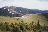
We woke to bright sunshine and a fine mist rising from the river after an all night rain. Everything was wet but beautiful. The trail was nice, recently maintained and rebuilt, with very little snow. It was a good choice to do the lower route. We climbed back up toward the CDT on a jeep road past the old Monarch Mine. It isnt currently in operation, but it hasnt been that long since it was. There were pretty views of green valleys along the road, though there are lots of clearcuts and burned areas too. The walking was easy with a few stream crossings. There were lots of ups and downs and the sunshine disappeared by mid-morning. We ate lunch at one of the view-spots.
Unfortunately it turned out that we were way off trail by then. Im getting a bad rep as a navigator. We turned off on the wrong jeep road and kept following it down the mountain. We wondered why the description didnt match the guidebook, but we were headed north and we were sure we knew where we were, so we didnt worry about it. We followed a wild creek for a while then started seeing houses with people. This seemed unlikely, but we soon crossed Ontario Creek, which was in the guidebook, so we kept going. Just about the time we figured out where we really were, we reached a road junction that showed we were about five miles west of where we were supposed to be and a couple of thousand feet lower. Oops! Fortunately we can get back to the trail fairly simply by continuing on the road to the highway, then climbing back up to MacDonald Pass. It will actually save us some time. However, its kind of a bad start: of our first four days on the CDT, three were off trail.
We saw a moose and three deer this afternoon. The only flowers I knew were gentians, shooting stars and mule ears. Jims knee is erratic, but at least hes not in constant pain. None of us got upset at losing the trail. Aside from one comment from Dave, I knew we should have turned right back by the mine, we all just accepted that as long as were heading generally north, were all right. The fact that this will help us make up for the lost time of the past two days instead of costing us time helps. Im not sure how far we ended up going today, but since we were on the trail about 8 hours and the hiking was easy except for the uphills in the morning, Ill assume about 15 miles. Thats what my body says anyhow. Its tired.
Were going to go into Helena, after all, tomorrow. Theres an outfitter there and our bad filter and Daves stove both need to be replaced. With all the rain and snow weve been having, Dave doesnt like having to fuss with his Zip stove. Gas is faster and easier when youre tired and the day is wet.
Jim: Lots of road walking - mostly because we took a wrong turn. We ended the day at a primitive FS campground along the Little Blackfoot River. Gotta learn how to use this altimeter. My Avocet broke a week before we started - so I bought a Suunto - but havent had time to learn how to use it yet.
Thursday, June 3 -- 10 miles to Helena
It rained all night, eased up a bit when we got up, then drizzled the rest of the morning -- a misty moisty morning. We walked through pretty ranch country for about four miles, past several horse farms and the river. Then we climbed six miles through the fog on the highway to MacDonald Pass and Frontiertown, where we had a maildrop. A couple of trucks stopped to ask if we needed a ride. Frontiertown is an odd place, built as a tourist attraction in the 1940s to resemble an old frontier fort. It has a couple of restaurants, one with steaks and seafood, the other gourmet Italian. They only serve dinners, unfortunately. It is partly a cave, built out of big heavy rocks with huge wooden beams and hand carved log chairs and tables - very rustic. The whole place is large with a small stable and pond and several springs. The owner, Richard Peg, is very nice. He showed us around, gave us a very welcome cup of hot coffee and a warm place to dry off, then drove us into town. He invited us to go back this afternoon and stay there for free, but I wanted to clean up and do laundry and run errands, so we stayed at a Days Inn instead.
We got the scenic tour of town on the local bus that took us to the outdoor store. They fixed our filter (not!) and we picked up various odds and ends, including juice, bananas, cheese, etc. at the grocery. Finally we returned to the motel for a hot shower and laundry. All in all it was a good day, busy but effective. Tomorrow well go back to the trail, come rain or shine. I feel good overall. A bit stiff, but no major aches or pains and my mood is good. Hiker hunger has already hit. The bowl of chili at lunch was very welcome after our long walk in the rain.
Jim: Today we paid the price for the lower elevation trail over the last two days - a long (and very wet) climb to along the highway the top of the ridge. The hospitality at Frontiertown was exceptional - Richard Peg seemed to be somewhat impressed by what were attempting to do. I like him. Town was welcome. We ate then went to the outdoor store. Im not happy about the failure of the water filter - its not that old. The guy at the outdoor shop worked on it, said it was fixed well see. Dave managed to replace his stove and theyll mail the Zip stove home for him. We searched for a salad bar for dinner, but the search ended in failure maybe next time.
Friday, June 4 -- 14 miles
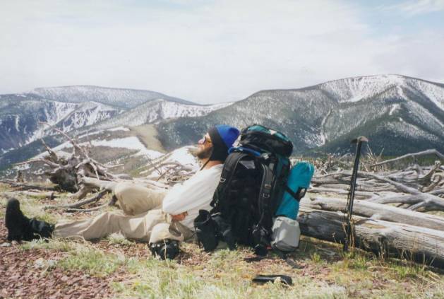
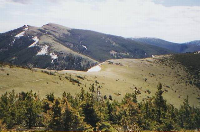
We left Helena about 9:00 a.m. after a free breakfast at the hotel. A $30 taxi took us back to Frontiertown and into the wall of fog that was hovering over the Divide. We climbed 1000' on a good jeep road, totally blind due to the thick fog. We scared up a family of deer. The wind on top was fierce as we passed an electronic installation, looking for a road or trail heading north. We finally found it, after staggering around for a few minutes, and descended into trees and snow. It was rocky trail, but well blazed with CDT markers. We crossed several meadows and passed through trees covered with thick, almost fluorescent, green moss. It was very pretty. We descended below the fog and ate lunch in a windy meadow. It was relaxing, though cold.
We didnt make that many miles today, and they were hard miles for some reason. Partly it was the late start and heavy packs (five days food!) The trail was mixed, with some very good clear tread, some blazed way with no obvious footpath, some jeep roads, and one little episode where we climbed a hill we werent supposed to climb and had a tough time bushwhacking back to the trail. There were lots of CDT markers, fortunately, though a few more at critical junctions would be nice. The afternoon was mostly sunny. There were clouds, but no rain. We had some lovely walks up open hillsides with incredible views, then nice stretches in the trees where we were protected from the wind. We saw lots of wildflowers, including some really pretty tiny purple orchids (calypso?) and one hill that was covered with white Spring Beauty and yellow lilies. Were starting to see some red and yellow paintbrush too.
Im worried about Jim. His twisted knee from a few days ago continues to plague him, along with a host of blisters. We are all slow, but I know he gets depressed at slowing us down, and worries about injuring himself worse by pushing so hard hed end up having to leave the trail. I pray not. He is the best of companions, even when hes in pain. I just ache and am tired, hungry and cold. Normal for long distance hiking. I feel guilty about enjoying myself so much when hes in pain, but he wouldnt want me to be miserable too.
Saturday, June 5 -- 14 miles to Black Mountain.
It was a strange night. Just about 8:30 p.m., as we were settling into our sleeping bags, a pick-up truck pulled up on the jeep road, stopped by a big snow bank that blocked the road. The men in the truck saw our tents in the trees and came over to investigate. They were very drunk and looking for trouble. They kept asking if we had any cans, which Jim explained later was because they wanted something to shoot at. They aimed a rifle at the water bottle in front of our tent, but didnt shoot. After about ten minutes they took off. I stayed quiet because I didnt want them to know there was a female there. It seemed wisest to avoid trouble, so we packed up all our gear and moved on about 3/4 mile up a side hill, well hidden. It was a terribly uncomfortable campsite but we didnt have much choice. The view almost made up for the slope and non-stop wind. Jim heard the truck come back a little while later. None of us slept much.
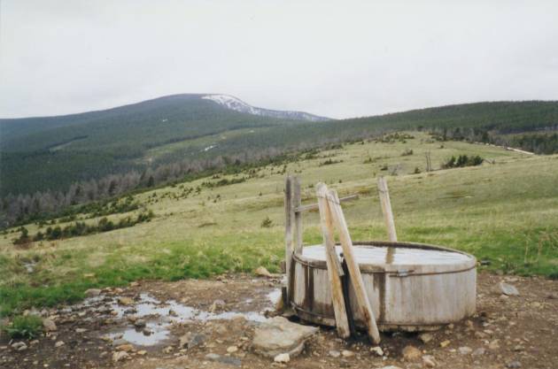
We skipped breakfast, then stopped about 9:30 a.m. to eat cold cereal. There was no sure water between MacDonald Pass yesterday and Dana Spring, a cattle trough where we ate lunch, though because of the snow melt there was a tiny unmarked spring yesterday afternoon that gave us enough to get through the night as well as a little water about a mile and a half before Dana Spring. Of course, there were some snowbanks in the trees, though they mostly just made mud, not streams. There were big black clouds all around, but no rain. In honor of my glum mood, the cold windy day and a sure water source, I made hot chocolate for lunch. We werent in a hurry to move on, though we needed to make some miles.
The afternoon was spent playing in the snow. Climbing Black Mountain wasnt too difficult, but we lost the blazes on top, then tried to bushwhack to where we thought the trail should be, only to discover that we were heading west instead of north. We bushwhacked back in the other direction through dense trees and eventually found the trail again. That was really scary for me as the mountain was VERY steep. It is very rocky in this section, so walking on snow is almost preferable, but it is very slow going. It was cold so the snow was firmer today, but we still break through knee deep or more every 5 - 10 steps. We all hurt so we stopped early in a gap between Nevada and Black Mountain. Jim stopped feeling his toes, so, rather than risk frostbite, we set up camp in a windy gap. There was a really nice view off the cliff edge of snowy rocks and snow-free meadow ahead.
We got some rain and sleet as we were hiking. Not a lot, but enough to get us damp all through. Its funny, I knew this can be a cold trail, with snow any week of the year, but knowing mentally isnt the same as dealing with it every day. We wear our long underwear tops and supplex pants all the time. As soon as we stop for a break, out come the fleece jackets and hats. The moment we stop for the day, we change into dry clothes and sometimes lie in the sleeping bags for a while until we warm up again. It is almost impossible to do anything about getting clean. The water is snowmelt and icy cold. Im lucky if I wash my face once a day. Yech! We stink, because, despite the cold, we still sweat climbing the hills. All in all, despite frequent bouts of sunshine, it feels much more like March than June.
Jim: Last nights episode with a couple drunken yahoos is still bothering me. I dont take well to having guns pointed in my direction - my instinct is to get very, very violent. But that wasnt the time. I also dont take well to being hunted - and theyve been looking for us Ive seen and heard the same truck several times. Theyve done this before - that was plain from the conversation when they first found us. If they find us, I promise they wont enjoy the results. The hike was more than a little rough today at one point I thought wed lost Ginny in the snow. For a while on Black Mountain there were blazes on every other tree, then they disappeared just where the trail switchbacked down the mountain. We ended up bushwhacking straight down through heavy snowpack not nice. We set down in the middle of a gap buried amongst the blowdowns last night a desperation campsite if ever there was one. But it was getting dark when we found it. What makes it even more interesting is that one of the tent poles is broken smashed at one end. Its usable, but just barely.
Sunday, June 6 -- 15 miles
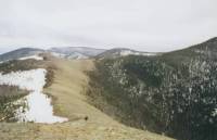
It was a difficult day, but an interesting one. Our first several miles were on snow. It was very cold last night so the snow was icy hard. It made it easier to walk on top of the snow, but also scarier going up and down. We had some incredible views off the edge of the escarpment, but some very exposed walking on the snow. We broke out the ice axes. I mostly did all right by just focusing on Daves footprints and not the slope below. My only fall was about five feet into a tree well. No big deal. We stopped at lunch and soon it started to snow. First a few flurries, then heavy snow. We didnt stay long. The sun came out about ½ hour later. We had nice hiking with intermittent snow all day. The weather here is so changeable: the clouds can be dark and ominous, then five minutes later the sun is shining. We call it Montana Weather.
The afternoon wasnt difficult walking for the most part, which was good since the morning was so difficult. We followed jeep roads much of the afternoon. Still, everyone is tired. Jim and Dave both have bad blisters that make walking painful. Our constantly wet boots really dont help. Finding a campsite was difficult but we finally found a flat spot hidden in the trees. We saw no wildlife, but lots of tracks, including a bears that we followed for a couple of miles. We see elk tracks almost every day, and coyotes, and lots of deer tracks, but no animals.
My mood is good today. I ache all over, but nothing specific. Jim was really tired and hurting, but food seems to be reviving him. Water was a problem. We melted snow for cooking dinner and breakfast, but there was no running water for about 14 miles, from lunch yesterday to about 3:00 p.m. today, and the water today was only a little snow-melt trickle along the road. It killed the filter again, but fortunately only after we had filled four quarts.
Jim: My boots have changed character. Ive used the same type of boots for a couple years - in Colorado and then again in Glacier NP last year. In both cases the boots got wet (after the Colorado trip it took them 3 weeks to dry out) but theyve never given me blisters before. But this time, theyve given me blisters on the inside of my ankles - both sides. And since our feet are wet almost all the time theres nothing thatll stick to protect the skin. Weve tried Moleskin, Duct tape, adhesive tape even Band-aids. So far nothings worked for either Dave or me. He has a big blister on the bottom of his foot. Makes it really painful to walk - for both of us.
Monday, June 7 -- 14 ½ miles
The day started out well with sunshine and blue skies. It was really cold though. Our boots were frozen solid and Daves water bottle tube was frozen so he couldnt drink from it. We had to start the day by looking for the trail since we took a wrong turn last night. We had several workable options, so we just flipped a coin and followed one of them. It worked, though we were in doubt for a while. We were nervous and edgy, but finally found a CDT marker and a stream nearby, which make everyone happy. I saw an old miners rocker down by the stream. We passed a couple of mines yesterday and lots of clear-cuts and old cut areas with lots of seedlings. The trail was very easy to follow, mostly side-hill and old jeep roads. There were some snow patches, but they were mostly flat and frozen nearly solid. We followed bicycle tracks through the snow for a while. That must have been an interesting ride!
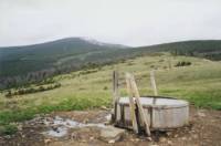
Lunch was at a rock outcropping with a fantastic view of the Scapegoat Wilderness, snow covered and beautiful. We had glimpses of those mountains all afternoon. It was too cold to linger, so Dave and I walked down the highway at Flesher Pass to get water from a culvert about 1/3 mile off the trail. There is a road to Lincoln there, the first of three possible routes to town. We climbed from the pass on good trail past some interesting red rock formations with lots of views. Then we turned a corner and the trail turned to solid snow. Since the trail was side-hill on a very steep slope, we had to make our way along a 10' bank of snow. Occasionally there were bare patches to let us know we were still on trail. It was exhausting and scary. Admittedly, it isnt far, but even a 10' fall into a tree could be dangerous. I got really upset for a few minutes, really scared, but finally went on. A few places I slid down on my backside. You dont get points for style out here, only surviving. It was a long couple of hours. We finally found a clear spot at a trail junction where we collapsed. I was more than ready to stop. We had a few flurries, but no real snow or rain. Still no animals, just some new wildflowers: lupine, yellow violets and tiny alpine forget-me-nots among others. I love the immensity and incredible beauty of this country. It lifts my spirits to look out and see the grassy hills and snow-capped mountains, especially looking back at the ones weve climbed, like Black Mountain and Nevada. But the cold is wearing, as is the snow travel. Im becoming a little more competent with the ice axe. Dave is a good teacher. His PCT experience is a real advantage. He just dances across the snow. I occasionally feel proud of myself at some of the places we traverse with relative ease. A few years ago those would have terrified me. Now I get tense, but I keep going. Im even learning to glissade, a little. Dave likes skiing down the snow banks, but I still get scared of losing control. Still, Ill slide occasionally. Sometimes its even fun.
Jim: Im really proud of Ginny - shes scared of the snow - in part because shes never had to deal with it like this. She didnt have a lot of snow while she was growing up in Arizona. But she just keeps on truckin. Ive never had to deal with this kind of snow either, but Ive done some snow camping and a lot of skiing. It helps. Probably also helps that Im not bright enough to be scared of some of the travel through the trees across narrow snow ridges between the 5 to 8 foot deep wells. What doesnt help is that my left knee is still bad and the right leg isnt getting any better - I damaged some tendons in my right leg on the AT and its come back to haunt me. I twisted the right leg in the snow a couple days ago and strained the tendons. Sometimes its OK - but then I stretch it the wrong way and every step becomes agony. I walked it out on the AT - lets hope it works this time.
Tuesday, June 8 -- 9 miles to Lincoln (Elev gain/loss: +3960/-6310)
We woke up to the slithery sound of snow sliding down the tent. It slowed a bit while I fixed breakfast, but returned as we hiked. It was nice hiking to Rogers Pass, despite the weather. It was warmer and not as windy as yesterday with a lot of up and down along the open ridges alternating with horizontal wind-driven snow. The rocky ground was carpeted with tiny alpine flowers. We saw signs of bear activity. He had been digging roots and moving rocks along the trail. Jims leg is really painful so we moved slowly but steadily down the trail. There was very little snow on the ground, nothing scary. We descended below the clouds to the pass and found sunshine. We waited about half an hour for a ride, and finally got picked up just before a big hailstorm hit. We found a nice big room: three beds and a fireplace, microwave and refrigerator. We visited the Post Office, had a chili omelet for lunch to warm us up and took a shower. Jim is ordering a new water filter to replace the one that was fixed and a tent pole to replace one that was broken in Helena. Were taking tomorrow off to await delivery and to allow time to heal a little bit.
Im worried about Jim. He has had a real problem with his boots. His feet are raw and he cant get bandages or moleskin to stay on for more than a couple of miles. He is still feeling the twisted knee and torn tendons from the first couple of days postholing in the deep snow. My feelings about the hike are mixed. Im glad to be here, but I hate seeing Jim hurting this much. The constant cold is wearing and the snow terrifying, but the country is so beautiful it is a constant joy. I dont want to stop, but it is hard!
Jim: Finally figured out some of what the Suunto altimeter will do. The cumulative elevation gain and loss functions are neat. Used those today for the first time. Lincoln is a good hiker town - it has everything you might need in a fairly compact area, as well as friendly people and good food. It is a long hitch off-trail though. Coming off the ridge was interesting Im having trouble walking so I was slow that made it cold, too because I wasnt moving fast enough to keep warm. Then we also saw grizzly diggings lots of them along the trail. The bear must have been following the trail too. Forgot the mention the wolf track we saw a couple days a go it was as big as my hand. But no fur.
Wednesday, June 9 -- Lincoln - rest day.
We took a quiet day off to rest and eat (and eat and eat!) There was lots of fresh snow in the mountains above town. We had only a few early showers, but mostly it was a sunny cool day. It got up to 51?! Im ready to get back on the trail though. I look forward to the Scapegoat and Bob Marshall Wilderness Areas. I wonder if well see any bears? We were able to access e-mail at the library to check for messages. There werent many since we havent really been gone very long, though it seems like much longer. We read old CDT Trail registers at the Post Office. It was fun to see so many familiar names. There is a real difference between those just starting and those almost finished. I was surprised at the amount of animosity some displayed. Why? Were all here because we want to be; no one is making us do this hike. If youre unhappy, its easy enough to go home. There arent a lot of CDT hikers--only about five a year signed the registers--and we vary a lot in attitude and aptitude apparently. There were more women than I expected, and I knew many of them, or at least, I knew of them.
Jim: This is our second night in Lincoln. The register was really interesting - its amazing how many of the names are familiar. Dave and I tried on some boots, but there was nothing that fit all that well. We also bought a gallon of Coleman fuel at the hardware store - well use what we need and leave the rest at the hardware store for other hikers. We ordered a new tent pole yesterday - its been awkward, although not impossible to set up the tent with the broken pole. The water filter is also being replaced - the fix in Helena was a bust.
Home | Links| Trail Journals |
The Thruhiking Papers | Bun-bunMontana | Wyoming | Colorado | New Mexico
Created: Fri, 16 Jan 2004
Revised: 30 Sept 2016Copyright © 1999-2017 Spirit Eagle