|
 |
 |
 |
 |
|
|
|
|
|
|
Thursday, June 10 -- 12 miles
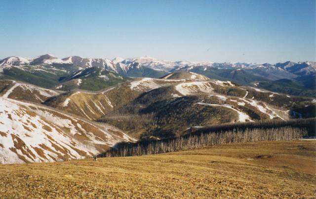
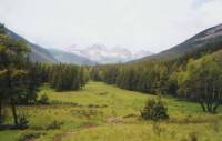
What an absolutely fabulous day. The sun is shining, the wind is blowing, the sky is mostly blue, and it is very clear. We can see for miles. It is about 50*, good for hiking, though cool for resting. We saw several townspeople in shorts and t-shirts, though they looked a bit cold. Everyone we met in Lincoln was very friendly. We left town after 9:00 a.m., getting a ride with a very nice man from Texas who has retired up here and now lives just below the CDT. We hit snow almost immediately above Rogers Pass, so we bushwhacked straight up out of the trees into open meadow. Very shortly after, I looked up to see Dave jumping up and down waving his arms. At first I thought he was just feeling good, then I realized he must be trying to get our attention. Sure enough, there was a grizzly bear on the trail about 100 yards ahead. He hadnt noticed us, and ordinarily we might have let it be, but he was blocking the route and we were far enough away not to be a threat, so we began to yell, bang our ice axes against the rocks, and jump up and down. The grizzly looked at us for a minute, then took off running down the hill away from our route. We were really jazzed. We made lots of noise after that.
We stopped for lunch on the side of a hill looking up at the next mountain we had to climb. It was a steep one, but the day was so beautiful, even our full packs didnt slow us down too much. I love being in the here and now. We can see east out to the Great Plains and south where we hiked the past few days and north up to the snowy mountains we have yet to climb. It is beautiful. We followed the official route along the Divide instead of the lower Alice Creek route, despite the lack of sure water along the ridge. It only cut off about two miles, but the views were tremendous. There was a little snow, but most patches could be avoided easily. We found a small rocky meadow with nice views to the south and even a tiny stream. Were trying to practice good bear country behavior: hanging food and cooking away from the sleeping area. We stopped early, by unanimous consent, as everyone was tired. The climb was over 4000' despite the low mileage. There was a relocation that added a mile or so over Green Mountain. It eased the climb a little, just not enough.
Jim: The man who gave us a ride out of town was standing in the hardware store when I brought the Coleman fuel back and talked to the clerk about leaving it for other hikers. I think thats why he stopped to pick us up. He invited us to stop at his place for a cup of coffee. We actually saw his house - about 2 miles away and 2000 ft down. The bear was the best part of the day though - cinnamon brown, definitely grizzly, probably about 600 lbs. Not full grown, but big enough. And fast very fast, when he started moving.
Friday, June 11 -- 10 miles
It was a difficult day all in all. It rained and snowed during the night, but the sun was shining as we ate breakfast. We walked along the ridge for a while through intermittent snow. Then we entered the Scapegoat Wilderness in a burned area and got in trouble. The trail disappeared in deep snow. The obvious way was straight up (and up and up!) We tried that, but the snow got softer and softer the higher we climbed and the trail got steeper. So we turned around and went back down. We tried contouring around the mountain, but it was steep and we could see no way back up to the Divide. Eventually, after much muttering over maps, we went back up into the soft snow. Fortunately, the deep postholing didnt last. I got through the climb by just concentrating on one step at a time. Plant ice axe, take a step, plant axe, step, plant axe, step. It worked, but very slowly. The top was snow free for about ½ mile, so we hurried toward a clump of trees for a brief lunch break. The wind was really whipping. I walked like a drunkard. It took 12 hours to hike 9-10 miles. The snow was bad, and worse, we got very lost. The trail wasnt marked at all and the treadway was deeply buried, so we did a lot of bushwhacking up and down. No such thing as switchbacks in deep snow; they vanish completely. At one point we ran into a small lake, thought it was Bighorn Lake, which was on the map, and tried to bushwhack up to the trail above. Unfortunately, we ended up doing a very steep climb up the wrong ridge. We sat on top of the narrow rocky ridge and could see the trail ahead but couldnt get there from where we sat. Worse, both Jim and I fell, badly, in the snow. He was able to grab a tree to stop his fall and only hurt his hand. I tried to jab in my ice axe but it didnt hold so I slid into a tree about 10' below. I was actually fortunate as there was a big branch that barely missed my ribs. I slid right under it to slam into the tree. I ended up with a few cuts on my hand, a swollen finger and a big bruise on my backside. I was lucky. My nerves were shot though. We had to cross talus and more snow. Every time anything slipped, I froze inside. A few times I froze in step, fighting my fears, as we were traversing, but I managed to keep going. It was an extraordinarily frustrating, difficult day.
We finally made a dry camp in a grove of burned trees. There is a nice view of snowy mountains to the west and some steep cliffs and a grassy ridge. The sun is shining and almost warm. Im not exactly happy, but Im as content as I can be at the moment. Everything hurts! Im still glad to be here, but it is very difficult for me. The men dance across the snow and rocks while I crawl. They wait for me a lot. But I do manage to keep going, even when the panic demon strikes.
Jim: Ginny had good reason to be nervous after her fall today - I was watching when she fell, but it happened so fast that there was nothing I could do. She only fell about 10 ft, but it was on an icy patch of consolidated snow and she slid into (or rather right under) a tree branch that Id looked at and thought Thats dangerous!. I have no idea how she missed being impaled. The end was only about 6" off the ground and yet somehow she slid right under it. Id barely missed it when I slid down there, but I wasnt in an out-of-control fall like she was. Something to think about - and sweat about - what would we have done if that branch had impaled her - or even just broken some ribs? Were a long way from help.
Worse yet the accident happened while we were climbing the wrong ridge. When we got up there we could see where the trail was about ¼ mile away straight up the ridge we were on. But wed have needed technical climbing gear to get there and we werent carrying that. So it took us another couple hours to make that ¼ mile by going back down the ridge, downstream from the lake and then up the next ridge.
Saturday, June 12 -- 15.5 miles
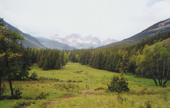
The pendulum swings back. We had lunch in a warm sunny meadow by the Dearborn River. Our morning had two difficult snowy spots but was mostly good dry trail. Even the shortcut that Jim Wolf recommends was easy to find and follow, for the most part. Another time we tried to second-guess the guidebook in order to avoid some snow; our gentle ridge ended in steep cliffs. I hate having to backtrack, but we had no choice. I froze crossing the first steep snowy section, so Dave cut steps. The snow was so hard I couldnt get my boots or ice axe in. Fortunately it wasnt wide. After that we followed good trail down through deep dark woods. Theyve added switchbacks, which adds mileage but made it much easier. There were lots of flowers: orchids, another pretty purple vine, orange paintbrush, etc. We made lots of noise to scare away bears, and saw none as a result.
We spent the afternoon in an easy ramble along the Dearborn River, climbing gently. We had several river crossings which got us wet above our knees. The water was fast and cold but not too wide. It was a little scary, but not too bad. It was more annoying than anything, as we had to stop to empty our boots and wring out our socks each time. The last part was through forest burned about ten years ago, with lots of blowdowns. I spent a lot of time on my knees, crawling under downed trees. There were lots of seedlings, grass and flowers, so it wasnt depressing, especially on such a fine day. Life does return. We decided to stop for dinner just past the fifth ford and hike on afterwards. Its good practice in grizzly country. We only went another mile or so since there was a nice campsite in a pretty meadow by a stream and the guidebook was pretty negative about camping possibilities beyond there. We would have liked to go farther to make up for the slow travel of the past week. On the snow I travel at barely one mile an hour. The river crossings also slowed us down and getting lost really eats up time. Were about ½ day behind schedule, not a real problem as we have extra food, but its annoying. This was the first day so far Ive been able to hike in short sleeves. Down in the valley it felt like summer. There wasnt even much snow above. Thats amazing considering the conditions during the past two weeks. Snow may be beautiful, but it is a real pain to travel in.
Sunday, June 13 -- 17 miles to Benchmark

The morning was easy, about a mile climb to Straight Creek Pass, then a long gentle descent along Straight Creek for 13 miles. The creek crossings were easy rock hops. My boots are finally starting to dry out. We saw our first columbine and lots of the purple orchids. We met three horses on the trail. Fortunately it is dry this week so the trail wasnt too muddy. You can tell it can be a problem sometimes. We saw some deer last night and a young buck this morning, plus a VERY fresh pile of bear scat (but no bears.) We had a hard time hanging our food last night since the rope kept getting caught up in the dead branches. The only trees were fire damaged. As Jim said, it is very nice to be hikers again instead of mountaineers. Our packs are light and the walking is easy along the creek with nice views of the water and up side valleys to snowy peaks. Life is good.
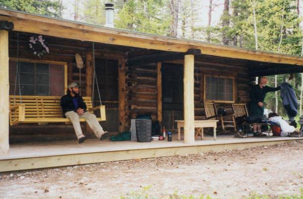
We made it to Benchmark Wilderness Lodge after a fast 15 trail miles and two slower road miles. The easy walking was harder than expected, since we went so fast. It really pounded the bottom of our feet. Dave soaked his feet in the stream and then we all collapsed when we reached the ranch. When we arrived we were met with the news (via a note on the door) that the owner had left 20 minutes before and wasnt due back until tomorrow. We were hoping for a shower, meals or a cabin. Since clouds were gathering, we were very disappointed. We searched for the wrangler, who found our food boxes (heavy with eight days of food!) and said we could use the bathhouse and camp on the lawn. We started to set up our tents, when, lo and behold, Beverly Heckman, the owner, showed up. She was nice enough to drive 30 miles from Augusta when she heard, via a passerby, that we were there. She opened up a cabin and offered us ice cream and salad. It was a welcome offer. We even got clean sheets for our feather beds. It is a very small resort, only 4 or 5 cabins with about 10 horses. Beverly has been running the ranch/outfitter/resort for 30 years. She was very nice. Best was the multitude of bird and hummingbird feeders and the salt licks. We saw lots of deer, including four bucks, and an orange hummingbird. It was a very peaceful place.
Jim: It was a good day - easy trail, good mileage, got a shower, resupplied, had salad and ice cream, the promise of some fuel for the stove, slept in a bed that didnt give me a backache. Daves new stove has been giving him problems ever since we left Helena, so today he tore it down and fixed it. We met some horsemen on the flat a couple miles from the road. They asked where we were going, so we told them Mexico. That got us some really funny looks, a question about whether we had a compass - and a comment that we were headed in the wrong direction.
Monday, June 14 19.5 miles to West Fork of the Sun River
We all slept well but were in no hurry to leave this morning. We walked the 1 ½ miles back to where we left the trail, then continued up the road to the trailhead into the Bob Marshall Wilderness. The only sign of life was the ranger who drove back and forth. We took the designated trail out of Benchmark instead of Jim Wolfs recommended route because there are pack bridges across two of the rivers. The recommended route includes a stream crossing across Pentagon Creek that can be dangerous at times of high water. As high and fast as the water is, we chose the safer route. It is shorter too, which doesnt hurt. Big black clouds are building so we could be in for a rain.
Beverly was holding boxes for a couple of CDT hikers who are due at Benchmark today. Weve been speculating about who they are, whether theyre thruhiking and if so, in what direction. It would be fun to run into other hikers, especially if theyre southbound and can tell us about the country ahead. However, given the multiple routes, we may pass each other without meeting.
The morning was easy as we followed the river upstream. There were occasional views, lots of meadows and lots of conifers. Dave saw two elk. I only saw the tail of the second one. There were three black and white harlequin ducks in the river and a couple of whitetail deer crossed our path. One posed before a pretty mountain, unfortunately too far away for a good photo. We saw bear and coyote tracks in the mud, along with elk, deer, etc. As we climbed, we could occasionally look down at the river, which was high and fast. Sure enough, eventually we got to a crossing. However, it was impassible, too fast to cross safely. Since we knew the trail crossed back again a mile later, we decided to bushwhack upstream to meet it. We soon found out why they hadnt just routed the trail on one side of the river. First there was a side stream that was almost as bad as the main river. Dave tested it first, without his pack. It was fast, but crossable. Then we went up and down through thick willows and bogs. It was very slow. Finally we found the trail, back on our side of the river, and, soon after, a nice flat campsite nearby. The river isnt too wide here, maybe 10', but it is fast and deep. Just getting water from the stream for cooking is dangerous. Well have to cross it one more time tomorrow. Snowmelt has its own hazards. We had a couple of rain showers today (one heavy) and heard thunder not far away, but mostly it was warm and sunny. Theres still a lot of snow up higher and even where we are camped at 6000' there are patches of snow.
I really admire both the men. Dave is de facto leader over the rough stuff. His greater experience with snow and snowmelt has been a real help. Jim is in a lot of pain but keeps on hiking. Every time his leg stabs him, like leaping across a stream, we find out about it, but there are times every step hurts and he just grins and bears it. They are both very good companions, especially in difficult circumstances.
Jim: We got fuel from the hostler at Benchmark before heading back into the snow. My right leg isnt getting any better its a rehash of the AT injury . Every time I stretch it, the tendons scream. But it wont get better if I stop, so I might as well keep on walking. If I dont walk it out, Ill end up crippled. And thats not acceptable.
Tuesday, June 15 16.2 miles
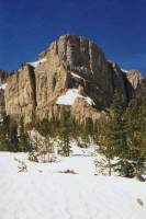
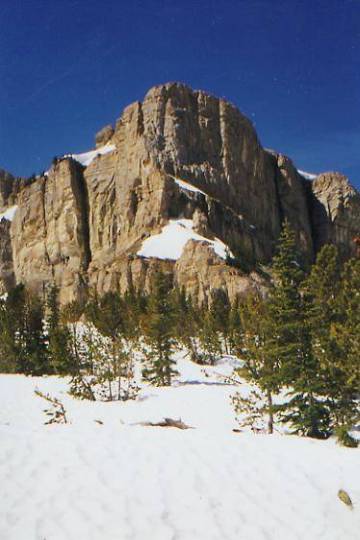
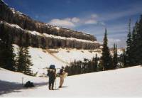
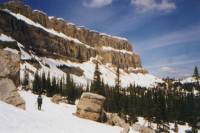
We crossed the river early in the morning, well fairly early. (Dave would like to start at 5:00 a.m. while Jim and I barely stir before 7:00. One of the hazards of partnership.) The water was only knee deep, but oh, was it cold! There is still a lot of snow in the high country and the river was pure snowmelt. We were just starting to feel our feet again when we had to do it again at Burnt Creek, just as deep and even colder. Not long afterward, we reached more open country, so we put on t-shirts and sunglasses as we continued to climb through the snow. Finally we reached the famous Chinese Wall, a huge cliff face that extends for miles. It is magnificent. We climbed to its base and will follow it for several miles. The view back was also splendid with snowy peaks everywhere. The sky is intensely blue. We lost the trail when we hit heavy snow, but the way has been easy to find. Problem is, it is really slow. Jim and I are turtles in this stuff. It is fairly soft, so its not scary since I can get footholds, but every step is an effort. Poor Dave is constantly waiting for us. He tries not to get impatient, but it is hard for him to have to wait. The snow didnt let up all afternoon. We went up and down and sideways over the slopes. When we were ready to stop for the day, there was no place to camp; there was too much snow. So we kept going until about 8:00 p.m., when we created a couple of tent sites in a small hollow below the trail. We all hurt and were exhausted. Dinner was light mashed potatoes since I didnt think our stomachs would handle more. We were too tired to be hungry. Tomorrow shouldnt be quite as bad. We chose the longer lower route to Gates Park to avoid snow and snowmelt. Well see if we were right. The views are awesome, but the walk was too much of a slog to really enjoy it. Route finding was mostly pretty easy since we paralleled the Wall most of the day, then went over a hill to frozen My Lake, switchbacked down to Spotted Bear Pass, then continued down the trail until we couldnt go any farther. It was very warm all day. Jim and I both got a little sunburned. Only one pass was dry enough to have flowers and the only wildlife we saw were ground squirrels and chipmunks.
Jim: It was the best and worst of days the scenery was unbelievable and we have it to ourselves. We havent seen even a footprint for two days - unless you want to count elk, deer and bear. But the walking has been mostly over snow and thats extremely painful for both the left knee and the right leg. But I still wouldnt miss this for any reason.
Wednesday, June 16 15 miles
We slept fairly well, despite our desperation campsite. Even the lumps were comfortable ones. We didnt hang our food (dumb) because the trees were really bad for bear bagging and we were too tired to go in search of better ones. All morning we followed bear tracks down the trail -- a cub with a female and a very large one headed in the other direction. We know theyre out here. We had lots of stream crossings this morning. Only the one just before lunch Red Shale Creek was bad. It was high thigh on me and very fast. We did one crossing on a log, a couple of shallow wades and a rock hop. It was a warm sunny day. Lunch was in the shade of some burned trees. The whole area was burned in the fires of 88. The morning walk was an easy descent in dense forest. There were few views, but looking for bears kept us alert. Aside from sore legs from the snow travel, I am content. We are back in summer, mosquitos and all. Yesterday was winter. Tonight, who knows? We climb from here.
After six miles of walking through burned forest, I was really happy to see live trees, but the snow began again almost immediately. We climbed into the snow, which soon became continuous. We ended up with another makeshift campsite on a ridge above the trail. We worried that there would be no dry spots for several miles, so Jim got adamant and found a sorta flat spot for us. Its not much, but it will do. After yesterday, I was in no hurry to end the day climbing in snow looking desperately for a place to camp. We have snow all around us, but we created a little dry nest in the bear grass. There werent many views this afternoon, just a glimpse of the Chinese Wall. The best part of today was the easy descent this morning. The worst part was the burned forest with its many blowdowns. One good thing was an unexpected bridge over Red Shale Creek. We had been following it all afternoon, and it was a rushing torrent. Even as we climbed, it still sounded fierce. But the second crossing was bridged. They bridge some of the tiny feeder creeks, but rarely the big ones. It was a nice surprise.
Jim: Lots of practice with stream crossings. Theres something really depressing about walking through burned-out forest. This wasnt one of our better days, so when we got into serious snow at the end of the day with no good campsite prospects, Id had enough and found a place to camp. Stealth camping at its most unobtrusive - 200' straight up the hill on top of the ridge. But no snow.
Thursday, June 17 about 15 miles to Open Creek
It rained in the night, a good loud thunderstorm, and we woke to gray skies and gray rocks, and soon, more gray burned trees. The Gates Park Route didnt impress me much. Yes, there are cliffs, but the dead forest definitely detracts from the beauty. We did see two beautiful waterfalls. We lost the trail in snow and deadfall and went way too low looking for it. We reached an impassible stream in a narrow cleft and had to backtrack. I was hurting (pulled tendon in my ankle) and crying with pain and frustration when we finally found the trail again. We go so slow in the snow, and where it is melted out, the mud is really thick and slippery. It is so aggravating.
We wallowed in snow all day. Occasionally we found signs of the trail, old blazes, cut logs, even clear path, but around the next bend we would lose it again. At the end of the day we were 1/10 mile from a trail junction, though the GPS cant agree with itself in which direction. We dont know where to go. The descent to Open Creek is at least 200' straight down an open snow chute. Terrifying, though I find I mind the open slopes less than the narrow icy drifts between trees. Im not a good tightrope walker. Those terrify me. On the open slopes I can just focus on following Daves footsteps. Trouble is, his stride is twice as long as mine. I take two steps to each one of his. Best is when the slope is gentle and I dont have to follow in his footsteps. We spent about an hour discussing what to do and wandering back and forth along the ridge above the creek looking for alternate routes down before we decided to call it a day and camp in the trees above the creek. We were too tired to tackle the descent. One problem is that the valley of Open Creek is narrow and steep and the water is high and fast. Most of our crossings today we did on snow bridges. Our feet still got soaked from snow and wet trail, but it wasnt dangerous. The cliffs really were beautiful, when I was able to look up from my feet to enjoy them, and there were several waterfalls.
It was a hard day. I cried several times - a mix of exhaustion, pain, frustration, and occasionally relief at making it across a scary part. I hate being such a wimp, but the snow traverses really scare me. Jim is great. He is so patient with my fears. It helps a lot. Dave just keeps on going, then waits patiently for us to catch up. We would be more cautious, and much slower, without his example of how easily it can be done.
Jim: Another long, long day of snow traverses - miles kicking steps in it with the only relief a fortuitous dry patch where we had lunch. Route finding isnt all that hard - were still following the Chinese Wall. But figuring out where the trail goes when it leaves the Wall is another story. Were at that point now, and cant agree on which drainage the trail follows away from the Wall. Dave thinks its down the snow chute that where we lost the trail. He may be right, but Im not willing to find out tonight were all tired and we dont need an accident here. We found a horse camp thats dry and relatively flat so well stay here tonight and try again tomorrow.
Friday, June 18 -- 19 miles
The descent was almost as bad as I feared. Dave glissaded down, while I just sidestepped very slowly down the slope. This would have been a good place to learn ice axe self arrest, but we were in too much of a hurry to play. Then we had to look for the trail, buried deep under the snow. The trail parallels the river though, so we found it and spent the morning alternating between snow, mud and decent trail. It was mostly just an easy walk in the woods. There were a few short icy stream crossings, a couple of snow bridges, and a few that we were able to jump across. There were even a few real bridges. Lunch was at Round Meadow, an open sunny area with a stream to one side and a nice log to lean against, with a view of snowy Signal Peak. It was early, but we had to stop to enjoy the beauty.
Our one concern, besides more snow, is that we are about a day behind schedule. We should have enough food if we dont run into other serious delays. So far, there has been no sign of other hikers since the first day out of Benchmark. This really is a wilderness - peaceful, beautiful and dangerous. I think psychologically it will get easier when we get nearer the end of the section. I have been very aware of how far we are from help if something goes wrong. There are no rangers out here and no other hikers. Just grizzly bears and elk.

The afternoon was different. We left the snow and some incredible trail work took care of a lot of the bog. (The Bob Marshall Wilderness is also known as the Bob, or less affectionately, the Bog, for obvious reasons.) The trail opened up in places so we had views of rivers, open green meadows, rocky hillsides covered in lupine, orange paintbrush and cream mariposa lilies. Strawberry blossoms are everywhere. We saw some enormous bear prints in the mud and piles of very fresh scat. We made lots of noise. There were a lot of blowdowns, so breaking branches as we went over and under the downed trees made our presence obvious. We had a couple of light showers, but no real rain. Strawberry Creek proved to be more difficult than expected, though given how high even minor stream crossings are, I shouldnt have been surprised. Our first crossing was 40 yards wide and high thigh deep. It wasnt all that fast, but there was a strong pull nevertheless. We crossed it again three miles later, at the end of the day. That one had two channels with an island in the middle. Not too fast, but a bit deeper. We cross it again tomorrow. Jim and I cross creeks hand in hand; so far it has worked well. He has a cold, to add to the trouble his knees are causing.
Jim: Its good to be off the snow for a while. We finally figured out which drainage was Open Creek and did the descent through the snow chute that we were too tired to do last night. When we got to the bottom of the snow chute, we found a trail sign that had been knocked over and was nearly buried in snow. After that the day got easier - except for the stream crossings. But those are getting to be routine, too. When you do 6 to 10 crossings a day they start to get that way. We stopped at another horse camp today nearly every stream crossing seems to have one.
Saturday, June 19 -- 15.5 miles to Elbow Creek
We had a deer stop by while I fixed breakfast. Utterly unafraid, she wandered around our campsite for about ½ hour. Later, Dave ran into a grizzly as he rounded a corner ahead of us. Fortunately it was afraid and didnt stick around. Jim and I never saw it. Dave was hiking ahead, as usual, and said it was a young cinnamon colored bear leaning against a tree, only about 100' away. Thats too close. The walking was easy this morning, though the streams proved to be time consuming. One was up to my hips; the others just take time to figure out the best route and to empty out wet boots. Late morning we hit snow, which slowed us down more. Finally we stopped in a beautiful meadow to eat lunch. There were snow patches, grass patches, steep bald granite peaks to the east, snowy white spruce-covered peaks to the south, and green spruce-covered knobs to the west. The sun warmed us up a little, but the wind blew cold.
The afternoon degenerated into a snow and bog slog. There were lots of big drifts blocking the trail. The occasional views were really nice and enough trail was showing to make route finding easy, but it was still a wet plodding day. We are wearing down I think. We ended up with a double creek crossing, short but deep and cold, at the confluence of Elbow and Muskrat Creeks. Theres a nice camp area at the junction.
We ended the day fairly well. There was a junction, not on the maps or trail guide. One side went straight across the hill, in the sun, with views. The other dropped into the trees and snow. We went straight, though we knew the trail drops eventually. For the next mile or more we were unsure as to whether or not we were on the right trail. However, it went in the right direction, so we kept on going. Fortunately, it worked out, though when we looked out and saw the rivers we had to cross at the end of the day, we wondered.
One incident was interesting. As we passed through a swampy meadow, we heard a sound like the barking of a seal. We all stopped and looked at each other. It repeated, a couple of times. We finally decided that it must be a distressed elk or moose (or bear). We never saw it. We made lots of noise and left quickly. How odd. In another boggy meadow, we could hear water boiling and bubbling out of the ground.
The best part of the hike is the beauty. The worst is feeling like were being pushed. Everything slows us down: the snow, the rivers, mud, injuries and just not wanting to be pushed. Since Dave is so much faster than we are, were always hurrying to catch up. He likes early starts; we like leisurely mornings. The conflict remains subtle, but both sides get frustrated. Dave could easily do much bigger miles without us, but needs our company going through grizzly country. Without his help on traversing the snow and looking for the route, Jim and I would be even more behind schedule, but sometimes I resent always feeling slow and awkward. All right, I know Im slow and awkward, but I dont like it being so obvious!
Jim: We stopped a little early today at Lost Horse Camp yeah, another horse camp. We needed a break and some time to dry out.
Sunday, June 20 21 miles

We got an early start (7:00) because we worried about snow at the pass three miles away. It turned out there was almost none. The stream crossings were easy, though the first was deep and very, very icy. Still, the current wasnt bad. Then we picked up some jeep tracks and the trail became very easy. We walked through open meadows filled with flowers, past aspen groves with new minty green leaves. There were views of snowy peaks in all directions. It was a beautiful morning. Dave saw a black bear disappear into the woods. Later we watched four elk cross the trail ahead of us and a couple of deer. The sun was shining, though thin cirrus clouds covered half the sky. There were some grey lenticular clouds for a while. We saw human and horse tracks for the first time since Benchmark. After so long with no signs of other people, I almost resented their presence. We passed a ranger station with a horse in the meadow, but no people.
This afternoon we met both the ranger and the people whose footsteps we were following when we ran into a trail crew building new trail above the river. They were from a wilderness drug rehab center. They had relocated the trail in several spots to avoid river fords. The views werent as good, perhaps, but it was nice to avoid the five fords, especially since the river was high and fast. We had a long chat with one of the groups of workers, then the ranger leading mules laden with tools, then with another crew leader who was too busy to chat.
We had dinner at Sawmill Flats, a big open meadow by the South Fork of the Two Medicine River, which we were supposed to ford. Ordinarily the river is two feet deep, but today it looked much deeper and very fast. There is an alternate route that will get us to East Glacier, but it is somewhat uncertain. But then, so is the river. I looked at the approach and there was no sign that anyone had crossed there recently so we decided not to try it. Instead, after dinner we continued another mile or so to a campsite in the trees.
Jim: A long day, with easy trail but a lot of up and down. I think this was our first 20+ mile day. No real navigation difficulties except that we took a couple trails that were unmarked but went in the right direction. Kinda makes you wonder sometimes - am I on the right trail? Ended up camped in the middle of an old, unused road with thousands of mosquitos and a short thunderstorm. The trail crews were the first people weve seen since Benchmark I think we resented the intrusion on our trail.
Monday, June 21 11.7 miles to East Glacier
We had a restless buggy night. The mosquitos and gnats were out in force. With a storm in the middle of the night, the heat and the bugs, no one slept well. It was too hot and muggy and we all felt dirty and itchy. We should have swum the river. We wasted an hour this morning, wandering around on gravel roads, proving the maps wrong. We finally found the Autumn Creek trailhead leading to the CDT, which was an overgrown, swampy, roller coaster. It was really bad trail with lots of streams cutting across, and lots of willows and bogs. We saw bear scat and footprints, but the country is so densely overgrown we might have walked right past one without seeing it. We banged and clanged and squished through the bog in the rain.
We arrived in East Glacier in time for a good lunch: hamburger and chili and a huckleberry shake at Mark Howsers Two Medicine Grill. Good stuff. Mark has been a good friend and trail angel. He offered us rooms at his motel, the Whistling Swan. We took them, gratefully. The hot shower was especially welcome after eight days in the backcountry.

Jim: The Autumn Creek Trail doesnt deserve to be called a trail. Its a mess - a wet, muddy, steep, overgrown, unmaintained roller coaster with little to recommend it - especially in the rain. A couple miles from town I decided I was hungry - RIGHT NOW. Town could wait - so I sat down to eat in spite of the chili and hamburgers and milk shakes that were waiting for me. Thats one version of hiker hunger - that you just arent going any further without feeding the machine. Not the last time Ill experience it, Im sure. It was good to see Mark again when we got to town and he does make a mean milkshake.
Tuesday, June 22 -- day off in E. Glacier.
It was a frustrating day for me, though some good came of it. Mark was going to Kalispell to drop a friend at the airport, so we went with him to look for new boots for Jim. His old ones caused a lot of grief. Mark had a rental car to pick up in Kalispell, so we picked it up and drove it back, taking care of business along the way. Trouble is, it all took forever. We left town at 6:30 a.m., drove an hour and a half to Kalispell where we had breakfast, then we visited three outdoor stores to get the boots and a smaller sized pack belt for Jim, then we went grocery shopping, then returned to E. Glacier. We went to Two Medicine Ranger Station to get our hiking permit, but were told that there was no computer and the ranger on duty didnt feel competent to help us with our permit. So we had to drive 45 miles to the Ranger Station at St. Marys. By then it was almost 4:00 p.m., and the ranger wanted to go home. We needed to mail out some packages and do a few errands and it was too late to do them by that time, so we have to stay an extra day. Since they only give permits 24 hours in advance (unless you pay an extra $20) we have to go back tomorrow to make our reservations and listen to the safety and Leave No Trace lectures. It was frustrating. The ranger, Dean, warmed up after a while, but at first he was really stiff and formal. The ranger at Two Medicine was merely ignorant, handing us a sheaf of out of date faxes about trail conditions and campground closings. She knew nothing about the trails and could give us no advice about what to do. Dean at St. Marys had a letter from two southbound CDT hikers regarding the snow conditions they found last week, which he let us read. Nice to know someone has been through here. It may be difficult, but it is doable.
The good parts of the day included a grizzly that ran across the highway in front of the car, a beautiful waterfall, and a double rainbow. Jim has new boots, his feet have an extra day to heal and we should be able to get a route through the park. The trails are open, even if the campsites arent. There will be snow, but it shouldnt be as bad as what weve already done. Tomorrow we can rest, and Ill be ready to face the cold and snow again. Id like to leave, but its snowing in the mountains, so an extra rest day sounds like a good idea.
Jim: A lot of driving, a lot of frustration, and well be stuck here for an extra day. But its not all bad - Ive got a new hip belt and a pair of boots. The old boots were eating my feet - Ive lost 8 toenails, 2 of them to frostbite in the Bog and the Scapegoat. Im a little worried about those toes. Maybe the new boots will give the blisters a chance to heal too. The extra day off will also give us a chance to rest.
Wednesday, June 23 - Day off in East Glacier.
We got our permits at Two Medicine. Sue Esh was the ranger today and she took care of us well. Well be going through the park slowly eight days to do 94 miles. The trouble is the reservation system: you have to stay at an authorized campsite, and the distances dont work well for thruhikers, especially since some of the campsites are still covered with snow. You cant camp if they cant find the outhouse. So we have some very short days. Since were uncertain about snow conditions in the park, that is just as well. Twenty mile days in heavy snow are not a good idea. We were told that all the trails have been hiked, but some are considered hazardous. They just opened the road through the park last week. It seems that since spring was cool, snowmelt is three weeks late this year. We checked e-mail at Marks. We know of three other CDT hikers who started in New Mexico, jumped up to Wyoming and ran into serious snow in the Wind River Range (200% of normal!) Willis walked the roads below the mountains for several hundred miles. Paul and Bill went home with the intent of returning to the trail in July. We may not meet them after all. Willis plans to meet us in or near Wisdom. There may be others out here, but the only ones we know about are Jason and Julian, who started a southbound hike in Glacier last week. They could pass us in Southern Montana. They were supposed to be at Benchmark last week, but are running late because of the snow. So are we, mostly due to a lot more time off than planned. It does our bodies good to eat and rest, but adds to the expense. It rained Monday and Tuesday; today was beautiful. I missed hiking but enjoyed the nap and extra ice cream. It felt good to have a real rest day, not one spent running errands. I finally finished the book I started three weeks ago, A Ladys Life in the Rocky Mountains, by Isabella Bird. She was a Victorian lady traveler who really makes me look like a piker. She was tough!
I look forward to returning to Glacier National Park. We hiked the CDT through the park last year since we werent sure it would be open when we got here this year. Our first three days will be a different route as we are following the lower elevation Belly River Route instead of the Highline Trail. The campsites on the Highline Trail arent open, and, according to Dean, we would need to rent bear canisters if we camped at undesignated sites. We know of three bad snow areas on the Highline Trail, so the lower route seems wiser, though it may not be as scenic. Well still have snow, but it shouldnt be as bad and some of the higher passes in the south end of the park will have melted by the time we get there, we hope. The good news is they put up most of the removable bridges last week.
Jim: Typical town stay - busy, busy, busy. But we managed to get in a nap this afternoon and Mark let us use his computer to access email. We leave tomorrow to do the Belly River route. The Highline Trail is closed unless were willing to go with undesignated campsites and carry bear cans. The campsites are still buried up there - they cant find the outhouses and the snow is so deep that the bear lines are only a couple feet off the surface. But its still late enough in the year that the bears are out - and hungry. We did the Highline route last year - I wouldnt enjoy doing it in that much snow.
Home | Links| Trail Journals |
The Thruhiking Papers | Bun-bunMontana | Wyoming | Colorado | New Mexico
Created: Fri, 16 Jan 2004
Revised: 30 Sept 2016Copyright © 1999-2017 Spirit Eagle