|
 |
 |
 |
 |
|
|
|
|
|
|
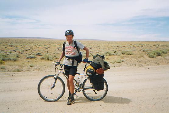
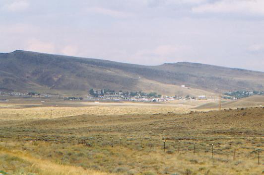
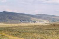
Tuesday, August 24 - 21 miles to Mormon Spring
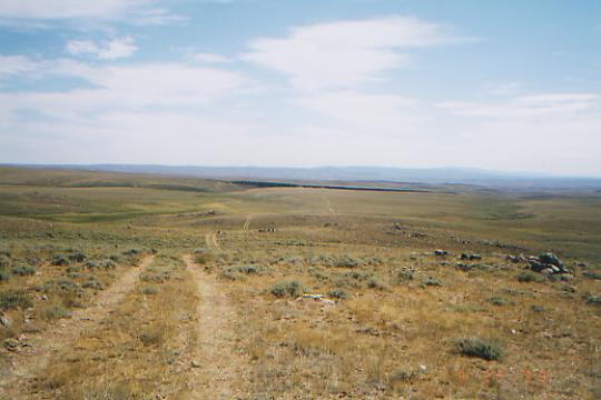
Were eating lunch on the Oregon and Pony Express Trails. Right here it is a jeep track that crosses the county road weve been following from Atlantic City. The official trail does a cross-country route about 100 yards off the road, but after half an hour of slowly picking our way through knee-deep sage and briars, bushwhacking from post to post, we decided to return to the road. A few vehicles have passed, but not that many. We met Tom, a Canadian long distance bike rider doing the Divide route. He was utterly flabbergasted that we were walking it. We also saw two antelope and a white horse - my first wild horse. It has been lightly cloudy, so cooler than expected, though the sun came out later. Theres some wind, but not the 60-100 mph gusts we were told to expect in Wyoming. Theyre very proud of the infamous Wyoming wind. To the north, we can still see the snow-touched Wind River Range. Southwest are the Oregon Buttes and Continental Peak. Eastward we see rolling hills and grasslands, with blooming yellow rabbitbrush and sage. We passed a few houses and trailers near town, but from here all we see is grass and sage, except in an occasional draw which holds enough water to support trees. Well cross the Sweetwater River this afternoon, but then well be in the desert, about 9 miles to the first spring, I think. The walking is easy but hard on the soles of the feet -- typical road walking. The nice part is being able to look around as we walk, watching for animals, hawks, plumes of dust indicating oncoming vehicles, etc. Its much nicer than watching your feet with every step, though there are limits. I wouldnt want to go all the way to Rawlins on gravel road, but a few miles is fine.
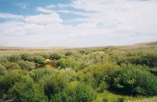
LATER: It was a long afternoon. The Sweetwater River was rather pretty, quite lush, with lots of tall willows and trees. It would have made a good place to camp, but it was early (2:30 PM) when we crossed the bridge, so we just got water and moved on. The sameness of the terrain got a bit wearing because it was hard to feel as if we were making any progress as we rolled gently through the grasslands. We saw four herds of antelope, plus another dozen or more strays. I have a good eye for antelope, it seems, though their big white rumps make them easy to spot. The second herd was napping in a grassy draw when we surprised them. We saw three horses by the Sweetwater, then a large herd (25-30) about a mile away. We also saw our first jack rabbits. Most of the afternoon was spent following the Seminoe Cutoff of the California Trail. Someone has put up concrete markers every half mile or so along the California/Oregon Trails. That must have been an expensive project! I enjoyed seeing the wagon ruts beside us and imagining what it was like to do this 150 years ago.
Finding Mormon Spring was interesting. It was in a pile of rocks in the middle of a large grassy draw that has been torn up by hundreds of years of animals drinking there. Clumps of grass grow between 18" ruts. There was water in the ruts, but we hoped for better, and were very lucky to find it.

The day stayed cloudy, though the wispy cirrus and stationary cumulus were replaced by solid grey. It looked like it might be raining to the west, but we stayed dry. The wind did pick up though. We looked for a sheltered spot to pitch the tent, but the sites in the rocks are rocky, and the spots in the grass are exposed.
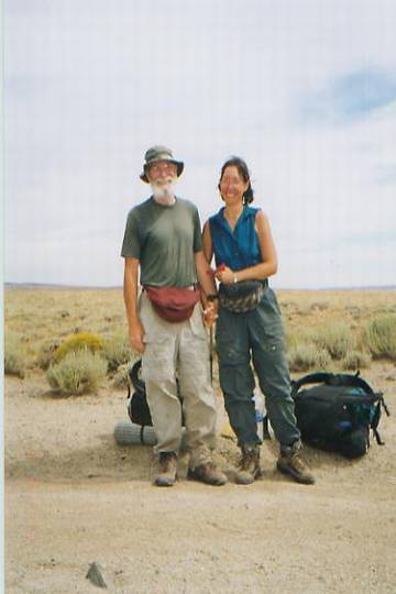
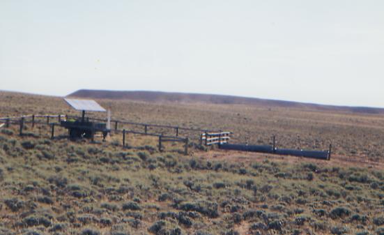
Our packs feel very heavy. We ended up buying lunch foods at the saloon (bread, cheese and candy bars) and now have too much. One bar/restaurant served breakfast and lunch, the other lunch and dinner. Both were pretty good. They get a lot of tourists on their way to South Pass. We hope to do this stretch in 6 ½ days, so we will have extra. One problem is we couldnt buy gas at Atlantic City, so we have to do this stretch quickly before we run out. We seem to be more or less following the official route, which is considerably shorter than JWs route. The BLM put up carsonite posts for most of the way to Rawlins. The BLM in Wyoming has been very helpful to the CDT hikers, willingly sharing information on the route and talking to us both before and after we hiked. Quite a contrast to the BLM in southern New Mexico, which would give out no information at all, even about the completed sections.
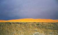
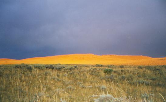
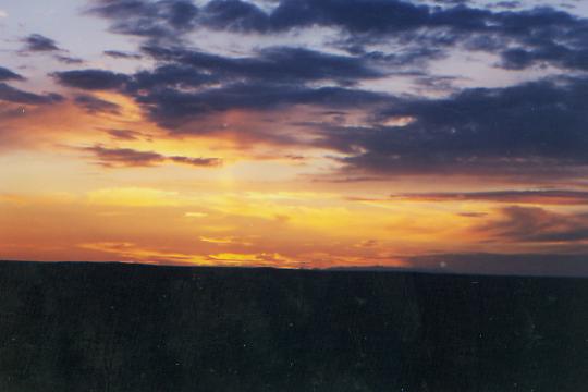
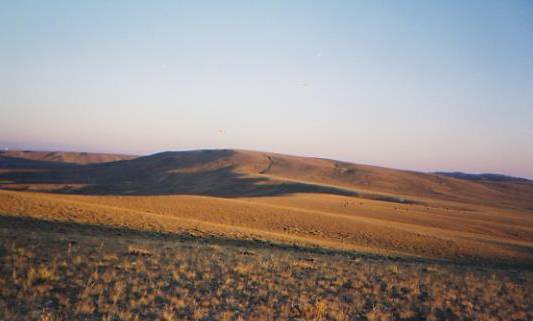
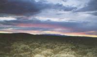
Just before sunset, the clouds lifted enough for the sun to light up the hills behind us. Their golden light was in sharp contrast to the black clouds behind them. An enormous rainbow framed the sight. It was gorgeous. On the other side, to the west, the sunset was golden, then pink and grey. The days must be getting shorter. We always used to be in bed at sundown; now we finally get to enjoy the sunsets.
Jim: The Canadian long distance bike rider was so astonished that he actually fell off his bike when he realized what we were doing. He passed us early, then we passed him where he was camped at the Sweetwater River. The Sweetwater would have been a good place to camp. Next time well just pick up the maildrop at South Pass City and stop at Atlantic City just for lunch then camp at the Sweetwater. Thought we were gonna get a good storm right at the end of the day, but it didnt happen. But we did get a beautiful sunset and a rainbow. Mormon Spring isnt easy to find.
Wednesday, August 25 - 24 miles to Crook Mountain
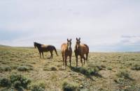
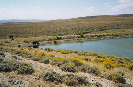
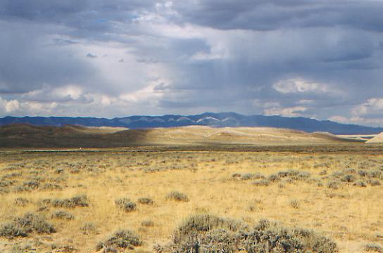
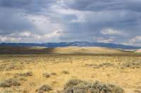
Lunch was on the grass by a scummy puddle in Coyote Gulch. We got water earlier at an iffy spring in Weasel Draw, but will probably get more here as the trail is longer than it appears to be on the map. There are lots of twists and turns as it follows the gulch. Weve seen lots of antelope this morning - at least 50 in groups of four to eight, plus a few loners. We saw a group of five beautiful black horses, running across the grasslands, and a large flock of grouse or quail and our first horny toad. And, of course, lots of cows and a couple of hawks. The black horses seemed to be playing with us as they wheeled and ran. They looked so free and beautiful. The sun is intense, but a few scattered clouds give an occasional respite. For a while we had some big boulder rock formations, then the Gulch had a good cliff face for a while. We are heading toward the Crook Mountains, standing blue on the horizon. I think we have finally seen the last of the Winds. It is incredibly dry here. In places the sage is only a few inches high and the grass is all brown, except in draws, where springs indicate their presence by the bright green grass surrounding them. It doesnt mean good water; sometimes just puddles between the tussocks, full of cow dung and worse. But we plan to pick up water any chance we get. Soon water sources will be 10 or more miles apart. Ray Hanson of the BLM warned us about the reservoirs. It hasnt rained in a long while around here, so the reservoirs may be empty, or just really scummy.
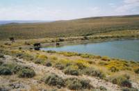
LATER: It turned out the next reservoir had plenty of water; the only problem was the 50 or so cows we had to chase away to get near it. We used the filter, then added iodine. We got water to take with us, as I doubt well make the next water source tonight. Unfortunately, the water bag has begun to leak around the valve. After an hour, the five quarts Jim was carrying were down to about two, so we stopped on top of a ridge to cook dinner. Well continue an hour or so after dinner, without the weight of the extra water, and feeling a little more rested. Weve done about 20 miles already today, and Im tired, but we need to get closer to the next water source before we stop. The afternoon was really dry as we walked past the white hills along Alkali Creek. There are more white hills on the back side of Crook Mountain, along with some trees. That was a surprise. Where we are now, though, is open ridge/plateau with no trees, but with beautiful views out into the Basin, back toward the Winds, east to Green Mountain, etc. Dark shadows in the valley below look like pools of water. We saw a few more antelope, but not as many as this morning, plus one very fast jack rabbit that startled me when it shot out of a bush beside us.

LATER: A final pull over a big hill finished us. We had time to put up the tent, enjoy a beautiful red and purple sunset, watch the full moon rise over the ridge ahead while two wild horses posed against it, listen to the yipping of coyotes, and spot a final antelope loping over the hill. We saw about 20 more in the past hour. Evidently, like deer, they disappear during the hot times and reappear at dusk.
Jim: This country is beautiful in a completely different way than the Winds. I love it, but it also demands respect. There are those who hate it I can understand that. There are those (thruhikers) who even skip this section I understand that, too. But Im very glad were here in spite of having to share water with the cows.
Thursday, August 26 - @ 28 miles to A&M Reservoir
Were sitting in the sun eating lunch near fenced Brenton Springs, roasting in the 90-degree heat. There is no shade, although there are a few scattered trees up the hill. The water here is pretty bad, as it was at the Haypress Reservoir earlier this morning. We found some decent water in Arapaho and Magpie Creeks, and got water at the latter. Our filter is already clogged almost solid. Cow turds and sand arent good for the element, I guess. We are pushing hard because of the water, but it feels as if we are going slowly.
We got up before sun-up, in hopes of getting a jump on the morning heat. We didnt even bother to make coffee, just ate some cold cereal, packed up and ran. The hiking was generally easy, over ridges and down draws. We lost the trail for a while, but picked it up again by accident. We didnt even know we had lost it. We were following a dirt road, and I just assumed they had run out of time or stakes and stopped marking the route. Ray Hanson of the BLM said he was coming back next week to finish marking the trail. Theyve done a good job so far, except at the one turn we missed. We have a long way to go this afternoon. We hit water about three miles after we started, then not again for another 11 or so. It should be easy walking this afternoon. Were finally heading out into the Great Basin instead of skirting the rim. So far weve seen 30 antelope and a bunch of cows, plus a lot of oil wells and pumps on top of one of the ridges. A falcon flew within 10 feet of me. We see a lot of hawks out here. Mostly we hear them first their cry is distinctive then we see them soaring overhead.

LATER: Today turned into a death march after all. We imagined that once in the flat basin, the walking would be fast and easy. We were wrong. In many places, the sand is 4-6" deep on the jeep track, and very soft. That makes for slow walking. We tried walking next to the road in the sage, and in many places the cows and horses had made parallel tracks. We didnt make it to the reservoir until 7:45, with barely enough time to get water and put up the tent before dark. There was another beautiful sunset. The good thing about this reservoir is that horses and cows are fenced out. The bad thing is that it is almost dry. We got some good water (we think) from a piped spring near Crooks Creek, about 9 miles back, so at least we dont have to pump water tonight. The hiking really got to me. The trail paralleled Green Mountain, seemingly forever. There was a sense of making no progress. We knew by 4:00 that it would be 7:30 or 8:00 before we reached water. By 6:00 p.m., wading through the sand, tired and hurting all over, we had had it. I started to cry. Jim just cursed the trail and the sand. Tomorrow, we have another day just like today. At the time I felt I just couldnt stand the thought of another 25 miles of slogging through sand. But I must stand it. We have no choice.

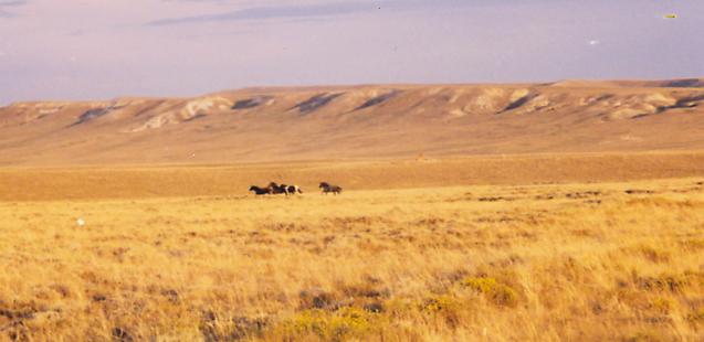
We saw four wild horses just before we reached the reservoir. I tried to get a picture of them running through the tall grass with the buttes in the background. I hope it worked. We saw another 20 or so antelope. The only flowers are the rabbitbrush and sage, with an occasional lupine and one firerocket gilia. We saw lots of prickly pear, though its only a few inches high out here.
Jim: Today wasnt all that bad until we crossed Crooks Road then the desert showed us what SAND is really like. It irritated me more than a little which isnt exactly logical but then who said I had to be logical? Weve also learned that the desert aint necessarily flat. It was a long, long day the last 5 miles were interminable and once again we got to camp (and water) right at dusk.
August 27 - @ 32 miles to Fish Pond Spring
We had a beautiful sunrise, but didnt get an early start due to the difficulty of pumping water through a clogged filter. With great effort, we get about an ounce a minute. We only pumped two quarts, since we had heard there was a new solar well up the trail. It turned out to be farther than expected (about 6 miles) and quite a way off the trail, but the water was better than most that weve drunk, even though the pump only ran for about a minute while we were there. Its set to get afternoon sun, not morning sun. The trough was full of water, so we filled up and put water in the water bag to carry until lunch. The hard part was trying to rig the bag so it wouldnt leak. The water stop took about an hour, all in all. Necessary, but not appreciated on a long day.
Lunch was eaten a few miles before Bull Springs. Weve been headed more or less straight southeast along the Bull Springs Rim, a line of brown grassy hills. Weve seen about 25 antelope, a bunch of horny toads, about 40 quail marching down to the reservoir to get water, a couple of rabbits hiding in a rock pile, many cows and one herd way off that was probably horses. There have been off and on clouds and breezes that cool us off a bit.
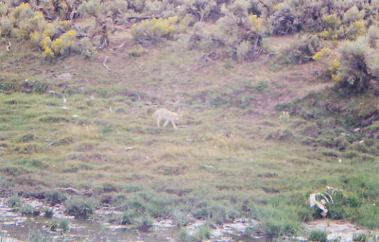
LATER: Tolkien said, Adventures are nasty uncomfortable things that make you late to dinner. I guess today qualified as an adventure of sorts. We were certainly late to dinner. We went to Bull Springs to get water for the afternoon and evening. It turned out to be utterly nasty and disgusting. The water seeps from the ground in a grassy draw full of cows. It was brown and shiny with green stuff growing around the edges and cow dung everywhere. Only a few pools were big enough to dip water; mostly it was just cow hoof prints full of water, though the flow half a mile downstream was better. There were two old (one year or less) cow skeletons and one fresh carcass above one of the spring areas. A coyote came to the water as we looked for a usable pool. He drank, pissed in the water, drank some more. He looked up at us and then ignored us, though we were only 25' away. He had to be sick. I started worrying about rabies, so we stopped looking for potable water. There was no way I would drink anything coming out of that draw! Then we missed the jeep track we intended to take from the spring to the road and ended up going east, then bushwhacking to another road that was heading in the right direction. A herd of antelope accompanied us for a while, running ahead, then waiting for us to catch up. The bushwhack was made difficult by the fact that the ground was completely covered with 2-3 prickly pear. Every step was a mine field. Finally we found the jeep track and a sign saying that recreational users were welcome on the private lands beyond the sign, and the walk became quite nice for a while. The hills were pretty, with orange and white patterns on eroded rock. A windmill raised hopes of water, but it was broken, and the cow pond below it was grey and mucky. Finally, we reached paved Mineral Exploration Road. We could see the highway about three or four miles ahead. Our feet hurt and it was getting late, but we had hopes of making it to one of the springs near the highway. A swarm of mosquitoes soon covered us. We were killing a dozen at each blow. We hurriedly pulled out the DEET, but still they swarmed. We had hundreds of bites. There are some nasty scummy grey puddles along the road--water for the cows I suppose--which make great mosquito breeding grounds. It sprinkled a couple of times as we walked, (felt wonderful), and there were some big thunderstorms a few miles away. We saw two rainbows over the Ferris Mountains.

Finally, we reached the highway. There was a spring there, as shown on the map, but it was lined with a lot of dead willows. This screamed danger, but we needed water. Even with iodine it tasted funny probably heavy metal or arsenic runoff from one of the mines above so we kept going without drinking more than the first taste. The next 15 miles are along a busy highway into Rawlins. I was so close to just sticking out my thumb as we walked along the highway and hitchhiking directly to Rawlins, but I knew that if I did, I would never come back to fill in this section. The main thing that stopped me, besides stubbornness, was the knowledge that probably no one would stop since the road is just too busy to stop safely and there were no pullouts. We did have one real chance for a ride, and we let it pass by. Were out here to walk from Canada to Mexico, even when the route stinks, but sometimes it hardly seems worth it.
It was getting dark as we headed up the highway. We walked three miles, then found we had missed the jeep road that turns off the highway toward the next spring. So we bushwhacked, in the dark, over to the track, followed it for about a mile to another turnoff, where we finally found water underfoot. We knew this was supposed to be a fenced spring, so we turned on the flashlight long enough to disclose a fence, with stile, and a good well buried deep in waist high grass. Victory! We got water to drink, ate Cheerios and cookies for dinner, and went to bed. Then we couldnt sleep because we hurt and were so dirty and sticky. But at least we arrived safely, thirty some miles from our starting point, with enough water to get us to town. We hope.
Jim: This wasnt one of our finer moments the walk south through the desert was as expected - long, but not unbearable. But even after some of the water sources weve used, Bull Springs was simply not acceptable. Wed have been better off if the water bag hadnt been leaking, but thats just wishful thinking. The walk to Mineral X Road was an extension of the desert, but dryer because our water was running low and by the time we got to the highway, it was gone. So the bad water at the road was a real disappointment. Then there was the walk down the extremely busy highway with no shoulder - as it was getting dark. We finally decided it was too dangerous to mess with anymore and bushwhacked to where we thought we might find the jeep track that wed missed. For once, something went right it was there. Then there was the question Should we just camp in the middle of the jeep track and look for the water in the morning? But we were both dehydrated by this time and wouldnt have been able to sleep, so the decision was to keep going and try to find the spring. We were either very lucky or very good and I wont guess which but we did find the water a beautiful covered well in a fenced meadow (protected from the cows). Once we got past all the dead bugs in the water, we just drank it no treatment. Of course, at this point we had nothing left to treat it with the filter was dead, we were almost out of fuel and wed used the last of our iodine. And we werent gonna wait to drink anyway.
Saturday, August 28 - 11.5 miles to Rawlins
We were up with the sun, anxious to reach Rawlins before the Post Office closed at noon. Walking the highway was really scary. There was a narrow paved shoulder that we walked on when we could since the ground beside the highway was slanted. Lots of semis use the two-lane highway. One group of 11 in a convoy nearly blew us off the road. I hated it. When the big rigs passed, I would stagger in their wake. We saw a large herd of antelope, but nothing else but a lot of sage. There are a couple of quarries. One was red, like pretty Brown Ridge at the beginning of the highway stretch. For the rest, we just walked as quickly as possible toward town.
There are no businesses along the highway, no restaurants or stores, since the main commercial area is along I-80 south of town. There are a lot of cheap motels in Rawlins, but few restaurants. We got a room, then went to pick up our mail. What a load! Its nice to have friends. We carried it to the Pantry, an old mansion turned into a nice restaurant, where we had hamburgers and salad and lots of Mountain Dew. They put us into a little side room all by ourselves. Do we smell that bad? Probably. Eventually, we got our hot shower. Heaven!
This stretch was really hard for me. We did 125 miles in four and a half days, including 11 miles in three hours this morning. Ouch. I hate pushing like that. I was so tempted last night to hitch a ride to town and just forget the stupid and dangerous road walk. Ive cried more in the past couple of days (exhaustion, frustration and anger) than I have since the snow crossings that used to terrify me. We need a rest. I have blisters on every toe and my enthusiasm is at an all-hike low. If we manage to sleep tonight, that will help enormously. The grocery is about two miles away, so well wait until tomorrow for that. Not being able to check e-mail is a disappointment. The library is closed on the weekend. We told several people we would check here, so it is aggravating to be cut off. Knowing that the trail out of town is another long road-walk is dispiriting also. One bit of good news, the blood blister on my finger finally came off, almost seven weeks after my accident. But I may still lose the fingernail. It looks very odd.
Jim has been terrific. When Ive felt tired and upset at having to push so hard, he hugs me, offers some jelly bellies (a gift from Sandy, thank you) or a joke. I know he hurts as much as I do, or more, but he rarely complains. He did say once that he sometimes envies my ability to clear the decks emotionally with a few quick tears.
We pass the half-way point this week. I know the next half will be different, with the coming of autumn. Well be back in the high country, with lots of big climbs, good views, and towns. We probably wont have the kind of isolation we had in Montana. But well finally have good maps and trails. I look forward to Colorado, despite my fears of snow and cold.
Jim: One of the things weve been doing all along is keeping trail notes for Jim Wolf (Continental Divide Trail Society). The Wyoming BLM also asked us for comments on this section. Most of our comments were about water sources, which is a separate issue from this journal, but the following is directly related and is an excerpt from my letter to the BLM about this section :
The absolute worst part of this section, though, was the road walk along Route 287 into Rawlins. That 15 miles is, very simply, an accident waiting to happen. Several years ago a young couple was killed on the Pacific Crest Trail under conditions that were far less dangerous than those which prevail on the Rawlins road walk. That 15 miles is along a 2-lane highway that's a main north-south route for fleets of 18-wheelers with a 1 ft shoulder. Sooner or later, some thruhiker will die on that road. Whos gonna take the responsibility for that? Wholl take the heat for it? Under the circumstances, I can only assume that this is another case of bureaucratic inertia and/or laziness for which some hiker will pay the price.I didnt like that road walk. Nuff said.
Sunday, August 29 - 4 miles around Rawlins
I dont know where the day went. Late arising, puttering, a call to Bill, the search for a restaurant that was open on Sunday (unbelievably hard Rawlins closes on the weekend), a long walk to the grocery, reading the new Backpacker, a couple of phone calls, and all of a sudden its evening. At dinner we decided to stay an extra day. Im not ready, mentally, to go back on the trail. I dread three more days of desert hiking and having to push hard for the next 150 miles. Eight days of food is heavy! After another day, well be eager to leave, I hope. Right now Im still physically and mentally exhausted. I tried to write a couple of post cards and could think of little positive to say. It has been good, even the desert, but so hard! I need time to get my enthusiasm back. I dont want to quit, but Im afraid of more of the death march stuff. We dont know about mileage or water for the next stretch; it could be as bad as the last, or worse.
Monday, August 30 - 2 miles in Rawlins
Another rest day. We tried, in vain, to get Internet access. Much time and running around ensued, but in the end, some problem with Hotmail and computer hackers put an end to our attempts. It was a busy phone day though: we talked to Kahley, Dad, Bill, Beau, Cindy, John O, Jim Wolf, Ray Hanson, Scott, Betty Sue Allen and Lynne Weldon, plus various banks and utility companies to attempt to straighten out a few problems back home. Whew!
Jim: This was one of those days when one (or both) of us just decided we werent ready to leave town yet. It happens. And when it does, the best thing to do is to go with the feeling. The last section across the desert took more out of us than we knew physically and emotionally. We didnt even go to the Post Office well mail everything tomorrow on the way out of town.
Home | Links| Trail Journals |
The Thruhiking Papers | Bun-bunMontana | Wyoming | Colorado | New Mexico
Created: Fri, 16 Jan 2004
Revised: 30 Sept 2016Copyright © 1999-2017 Spirit Eagle